You are here: Home > Network List > CN - Canadian National Seismograph Network Stations List
> Station INK INUVIK, NT > Earthquake Result Viewer
INK INUVIK, NT - Earthquake Result Viewer
*The percent match for this event was below the threshold and hence no stack was calculated.
| Earthquake location: |
Taiwan |
| Earthquake latitude/longitude: |
23.3/121.8 |
| Earthquake time(UTC): |
2017/09/20 (263) 14:29:56 GMT |
| Earthquake Depth: |
22 km |
| Earthquake Magnitude: |
5.3 Mww |
| Earthquake Catalog/Contributor: |
NEIC PDE/us |
|
| Network: |
CN Canadian National Seismograph Network |
| Station: |
INK INUVIK, NT |
| Lat/Lon: |
68.31 N/133.53 W |
| Elevation: |
44 m |
|
| Distance: |
73.8 deg |
| Az: |
21.985 deg |
| Baz: |
292.207 deg |
| Ray Param: |
$rayparam |
*The percent match for this event was below the threshold and hence was not used in the summary stack. |
|
| Radial Match: |
42.2437 % |
| Radial Bump: |
400 |
| Transverse Match: |
53.28926 % |
| Transverse Bump: |
400 |
| SOD ConfigId: |
13570011 |
| Insert Time: |
2019-04-28 20:00:03.005 +0000 |
| GWidth: |
2.5 |
| Max Bumps: |
400 |
| Tol: |
0.001 |
|
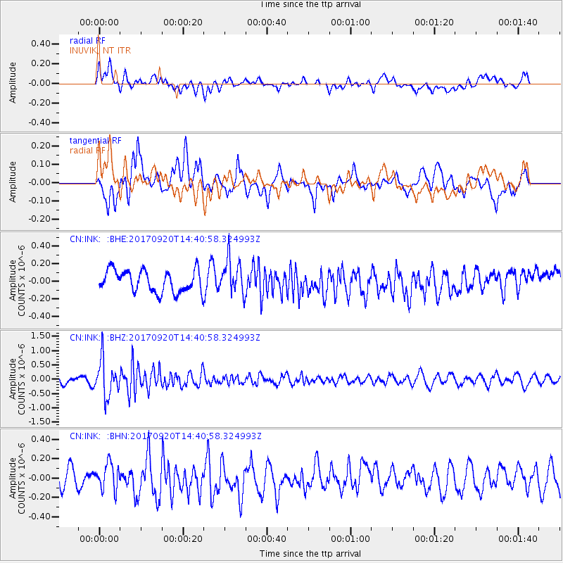
Signal To Noise
| Channel | StoN | STA | LTA |
| CN:INK: :BHZ:20170920T14:40:58.324993Z | 4.9989343 | 6.419874E-7 | 1.2842484E-7 |
| CN:INK: :BHN:20170920T14:40:58.324993Z | 1.1397914 | 1.4169593E-7 | 1.2431744E-7 |
| CN:INK: :BHE:20170920T14:40:58.324993Z | 1.6042435 | 2.0180116E-7 | 1.257921E-7 |
| Arrivals |
| Ps | |
| PpPs | |
| PsPs/PpSs | |


