You are here: Home > Network List > TA - USArray Transportable Network (new EarthScope stations) Stations List
> Station N10A Dunphy, NV, USA > Earthquake Result Viewer
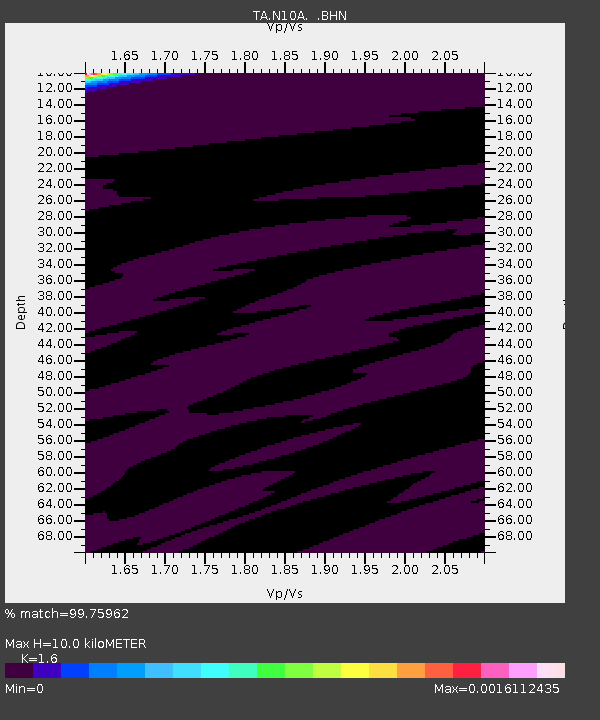
N10A Dunphy, NV, USA - Earthquake Result Viewer
| Earthquake location: |
Southeast Of Loyalty Islands |
| Earthquake latitude/longitude: |
-21.4/169.2 |
| Earthquake time(UTC): |
2007/09/28 (271) 11:12:40 GMT |
| Earthquake Depth: |
10 km |
| Earthquake Magnitude: |
5.5 MB, 5.8 MS, 5.8 MW, 5.7 MW |
| Earthquake Catalog/Contributor: |
WHDF/NEIC |
|
| Network: |
TA USArray Transportable Network (new EarthScope stations) |
| Station: |
N10A Dunphy, NV, USA |
| Lat/Lon: |
40.72 N/116.51 W |
| Elevation: |
1392 m |
|
| Distance: |
92.5 deg |
| Az: |
47.091 deg |
| Baz: |
243.893 deg |
| Ray Param: |
0.041441094 |
| Estimated Moho Depth: |
10.0 km |
| Estimated Crust Vp/Vs: |
1.60 |
| Assumed Crust Vp: |
6.276 km/s |
| Estimated Crust Vs: |
3.922 km/s |
| Estimated Crust Poisson's Ratio: |
0.18 |
|
| Radial Match: |
99.75962 % |
| Radial Bump: |
24 |
| Transverse Match: |
99.22663 % |
| Transverse Bump: |
36 |
| SOD ConfigId: |
2564 |
| Insert Time: |
2010-03-06 03:56:54.533 +0000 |
| GWidth: |
2.5 |
| Max Bumps: |
400 |
| Tol: |
0.001 |
|

Signal To Noise
| Channel | StoN | STA | LTA |
| TA:N10A: :BHN:20070928T11:25:20.200002Z | 0.9758173 | 1.7490018E-8 | 1.7923456E-8 |
| TA:N10A: :BHE:20070928T11:25:20.200002Z | 0.57095796 | 9.99809E-9 | 1.7511079E-8 |
| TA:N10A: :BHZ:20070928T11:25:20.200002Z | 1.0571203 | 1.5082986E-8 | 1.4267992E-8 |
| Arrivals |
| Ps | 1.0 SECOND |
| PpPs | 4.1 SECOND |
| PsPs/PpSs | 5.0 SECOND |


