You are here: Home > Network List > TA - USArray Transportable Network (new EarthScope stations) Stations List
> Station N10A Dunphy, NV, USA > Earthquake Result Viewer
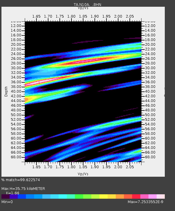
N10A Dunphy, NV, USA - Earthquake Result Viewer
| Earthquake location: |
Southeast Of Loyalty Islands |
| Earthquake latitude/longitude: |
-21.2/169.4 |
| Earthquake time(UTC): |
2007/09/27 (270) 21:05:33 GMT |
| Earthquake Depth: |
10 km |
| Earthquake Magnitude: |
5.5 MS, 5.4 MB |
| Earthquake Catalog/Contributor: |
WHDF/NEIC |
|
| Network: |
TA USArray Transportable Network (new EarthScope stations) |
| Station: |
N10A Dunphy, NV, USA |
| Lat/Lon: |
40.72 N/116.51 W |
| Elevation: |
1392 m |
|
| Distance: |
92.3 deg |
| Az: |
47.02 deg |
| Baz: |
243.911 deg |
| Ray Param: |
0.041485056 |
| Estimated Moho Depth: |
35.75 km |
| Estimated Crust Vp/Vs: |
1.66 |
| Assumed Crust Vp: |
6.276 km/s |
| Estimated Crust Vs: |
3.781 km/s |
| Estimated Crust Poisson's Ratio: |
0.22 |
|
| Radial Match: |
99.622574 % |
| Radial Bump: |
37 |
| Transverse Match: |
98.74332 % |
| Transverse Bump: |
42 |
| SOD ConfigId: |
2564 |
| Insert Time: |
2010-03-06 03:57:05.979 +0000 |
| GWidth: |
2.5 |
| Max Bumps: |
400 |
| Tol: |
0.001 |
|

Signal To Noise
| Channel | StoN | STA | LTA |
| TA:N10A: :BHN:20070927T21:18:11.600022Z | 1.086368 | 1.973356E-8 | 1.8164712E-8 |
| TA:N10A: :BHE:20070927T21:18:11.600022Z | 0.74414533 | 1.9683597E-8 | 2.6451282E-8 |
| TA:N10A: :BHZ:20070927T21:18:11.600022Z | 1.4832153 | 2.6908117E-8 | 1.8141746E-8 |
| Arrivals |
| Ps | 3.8 SECOND |
| PpPs | 15 SECOND |
| PsPs/PpSs | 19 SECOND |


