You are here: Home > Network List > GS - US Geological Survey Networks Stations List
> Station DEC06 Boomer, Decatur, IL, USA > Earthquake Result Viewer
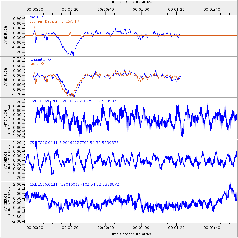
DEC06 Boomer, Decatur, IL, USA - Earthquake Result Viewer
*The percent match for this event was below the threshold and hence no stack was calculated.
| Earthquake location: |
Central Mid-Atlantic Ridge |
| Earthquake latitude/longitude: |
4.5/-32.7 |
| Earthquake time(UTC): |
2016/02/27 (058) 02:41:46 GMT |
| Earthquake Depth: |
10 km |
| Earthquake Magnitude: |
5.5 MB |
| Earthquake Catalog/Contributor: |
NEIC PDE/NEIC COMCAT |
|
| Network: |
GS US Geological Survey Networks |
| Station: |
DEC06 Boomer, Decatur, IL, USA |
| Lat/Lon: |
39.90 N/88.95 W |
| Elevation: |
215 m |
|
| Distance: |
61.6 deg |
| Az: |
313.337 deg |
| Baz: |
109.511 deg |
| Ray Param: |
$rayparam |
*The percent match for this event was below the threshold and hence was not used in the summary stack. |
|
| Radial Match: |
43.920166 % |
| Radial Bump: |
400 |
| Transverse Match: |
35.385086 % |
| Transverse Bump: |
400 |
| SOD ConfigId: |
1427151 |
| Insert Time: |
2016-03-12 03:11:55.659 +0000 |
| GWidth: |
2.5 |
| Max Bumps: |
400 |
| Tol: |
0.001 |
|
Signal To Noise
| Channel | StoN | STA | LTA |
| GS:DEC06:01:HHZ:20160227T02:51:32.533987Z | 1.9421536 | 5.9214864E-7 | 3.048928E-7 |
| GS:DEC06:01:HHN:20160227T02:51:32.533987Z | 2.2590969 | 1.2825485E-6 | 5.677262E-7 |
| GS:DEC06:01:HHE:20160227T02:51:32.533987Z | 1.5870365 | 6.993555E-7 | 4.4066755E-7 |
| Arrivals |
| Ps | |
| PpPs | |
| PsPs/PpSs | |


