You are here: Home > Network List > TA - USArray Transportable Network (new EarthScope stations) Stations List
> Station N10A Dunphy, NV, USA > Earthquake Result Viewer
N10A Dunphy, NV, USA - Earthquake Result Viewer
| Earthquake location: |
Southeast Of Loyalty Islands |
| Earthquake latitude/longitude: |
-21.1/169.3 |
| Earthquake time(UTC): |
2007/09/27 (270) 19:57:44 GMT |
| Earthquake Depth: |
9.0 km |
| Earthquake Magnitude: |
6.2 MB, 6.3 MS, 6.1 MW, 6.1 MW |
| Earthquake Catalog/Contributor: |
WHDF/NEIC |
|
| Network: |
TA USArray Transportable Network (new EarthScope stations) |
| Station: |
N10A Dunphy, NV, USA |
| Lat/Lon: |
40.72 N/116.51 W |
| Elevation: |
1392 m |
|
| Distance: |
92.3 deg |
| Az: |
47.052 deg |
| Baz: |
244.054 deg |
| Ray Param: |
0.041485216 |
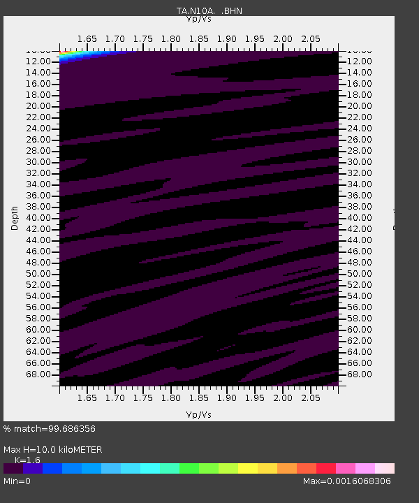
| Estimated Moho Depth: |
10.0 km |
| Estimated Crust Vp/Vs: |
1.60 |
| Assumed Crust Vp: |
6.276 km/s |
| Estimated Crust Vs: |
3.922 km/s |
| Estimated Crust Poisson's Ratio: |
0.18 |
|
| Radial Match: |
99.686356 % |
| Radial Bump: |
29 |
| Transverse Match: |
98.78129 % |
| Transverse Bump: |
46 |
| SOD ConfigId: |
2564 |
| Insert Time: |
2010-03-06 03:57:09.880 +0000 |
| GWidth: |
2.5 |
| Max Bumps: |
400 |
| Tol: |
0.001 |
|

Signal To Noise
| Channel | StoN | STA | LTA |
| TA:N10A: :BHN:20070927T20:10:22.650024Z | 0.7969969 | 1.9823501E-8 | 2.4872746E-8 |
| TA:N10A: :BHE:20070927T20:10:22.650024Z | 0.857391 | 1.4532182E-8 | 1.6949306E-8 |
| TA:N10A: :BHZ:20070927T20:10:22.650024Z | 0.5945068 | 1.3397696E-8 | 2.2535817E-8 |
| Arrivals |
| Ps | 1.0 SECOND |
| PpPs | 4.1 SECOND |
| PsPs/PpSs | 5.0 SECOND |


