You are here: Home > Network List > TA - USArray Transportable Network (new EarthScope stations) Stations List
> Station N10A Dunphy, NV, USA > Earthquake Result Viewer
N10A Dunphy, NV, USA - Earthquake Result Viewer
| Earthquake location: |
Galapagos Islands, Ecuador |
| Earthquake latitude/longitude: |
-0.6/-91.3 |
| Earthquake time(UTC): |
2007/08/29 (241) 22:10:10 GMT |
| Earthquake Depth: |
23 km |
| Earthquake Magnitude: |
5.6 MB, 4.8 MS, 5.4 MW |
| Earthquake Catalog/Contributor: |
WHDF/NEIC |
|
| Network: |
TA USArray Transportable Network (new EarthScope stations) |
| Station: |
N10A Dunphy, NV, USA |
| Lat/Lon: |
40.72 N/116.51 W |
| Elevation: |
1392 m |
|
| Distance: |
47.0 deg |
| Az: |
333.783 deg |
| Baz: |
144.466 deg |
| Ray Param: |
0.070225045 |
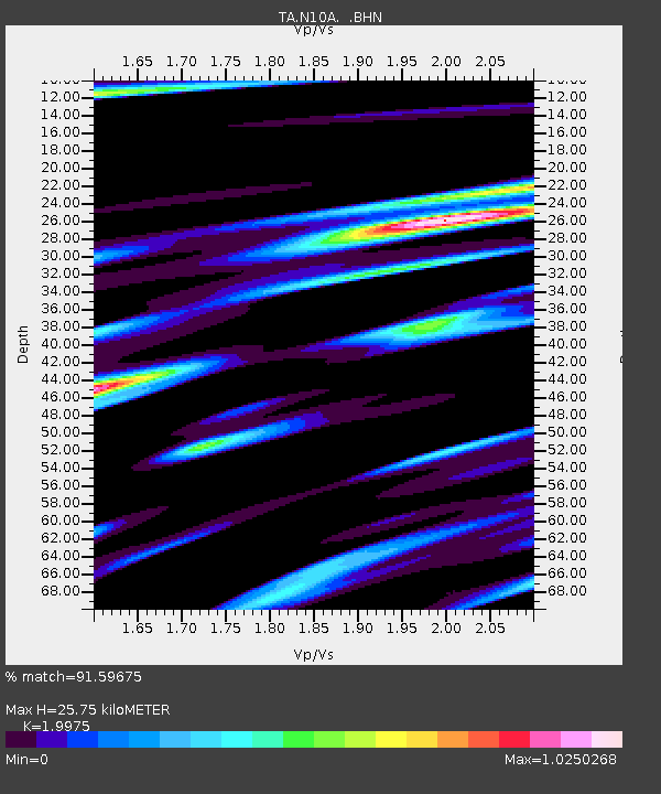
| Estimated Moho Depth: |
25.75 km |
| Estimated Crust Vp/Vs: |
2.00 |
| Assumed Crust Vp: |
6.276 km/s |
| Estimated Crust Vs: |
3.142 km/s |
| Estimated Crust Poisson's Ratio: |
0.33 |
|
| Radial Match: |
91.59675 % |
| Radial Bump: |
376 |
| Transverse Match: |
83.7994 % |
| Transverse Bump: |
400 |
| SOD ConfigId: |
2564 |
| Insert Time: |
2010-03-06 03:57:20.437 +0000 |
| GWidth: |
2.5 |
| Max Bumps: |
400 |
| Tol: |
0.001 |
|

Signal To Noise
| Channel | StoN | STA | LTA |
| TA:N10A: :BHN:20070829T22:18:09.199012Z | 2.0248017 | 2.5561175E-7 | 1.262404E-7 |
| TA:N10A: :BHE:20070829T22:18:09.199012Z | 1.4248859 | 2.0465858E-7 | 1.4363155E-7 |
| TA:N10A: :BHZ:20070829T22:18:09.199012Z | 3.3712642 | 3.775218E-7 | 1.1198226E-7 |
| Arrivals |
| Ps | 4.3 SECOND |
| PpPs | 12 SECOND |
| PsPs/PpSs | 16 SECOND |


