You are here: Home > Network List > TA - USArray Transportable Network (new EarthScope stations) Stations List
> Station N10A Dunphy, NV, USA > Earthquake Result Viewer
N10A Dunphy, NV, USA - Earthquake Result Viewer

| Earthquake location: |
Tonga Islands |
| Earthquake latitude/longitude: |
-17.5/-174.3 |
| Earthquake time(UTC): |
2007/08/26 (238) 12:37:31 GMT |
| Earthquake Depth: |
127 km |
| Earthquake Magnitude: |
5.9 MB, 6.1 MW |
| Earthquake Catalog/Contributor: |
WHDF/NEIC |
|
| Network: |
TA USArray Transportable Network (new EarthScope stations) |
| Station: |
N10A Dunphy, NV, USA |
| Lat/Lon: |
40.72 N/116.51 W |
| Elevation: |
1392 m |
|
| Distance: |
78.9 deg |
| Az: |
40.968 deg |
| Baz: |
235.422 deg |
| Ray Param: |
0.049030103 |
| Estimated Moho Depth: |
68.25 km |
| Estimated Crust Vp/Vs: |
2.09 |
| Assumed Crust Vp: |
6.276 km/s |
| Estimated Crust Vs: |
3.003 km/s |
| Estimated Crust Poisson's Ratio: |
0.35 |
|
| Radial Match: |
87.63282 % |
| Radial Bump: |
400 |
| Transverse Match: |
84.75083 % |
| Transverse Bump: |
383 |
| SOD ConfigId: |
2564 |
| Insert Time: |
2010-03-06 03:57:21.923 +0000 |
| GWidth: |
2.5 |
| Max Bumps: |
400 |
| Tol: |
0.001 |
|
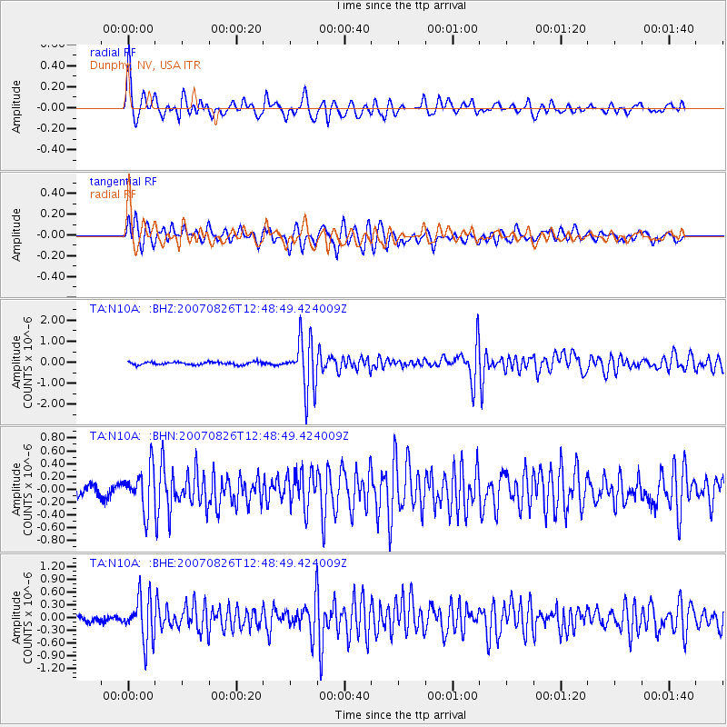
Signal To Noise
| Channel | StoN | STA | LTA |
| TA:N10A: :BHN:20070826T12:48:49.424009Z | 4.765761 | 3.3443186E-7 | 7.017387E-8 |
| TA:N10A: :BHE:20070826T12:48:49.424009Z | 7.935412 | 5.2600353E-7 | 6.6285594E-8 |
| TA:N10A: :BHZ:20070826T12:48:49.424009Z | 18.489346 | 1.2247158E-6 | 6.6239004E-8 |
| Arrivals |
| Ps | 12 SECOND |
| PpPs | 33 SECOND |
| PsPs/PpSs | 45 SECOND |


