You are here: Home > Network List > TA - USArray Transportable Network (new EarthScope stations) Stations List
> Station G16K Koyuk River, AK, USA > Earthquake Result Viewer
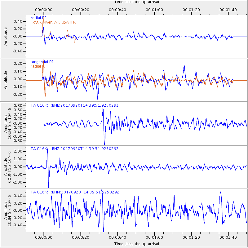
G16K Koyuk River, AK, USA - Earthquake Result Viewer
*The percent match for this event was below the threshold and hence no stack was calculated.
| Earthquake location: |
Taiwan |
| Earthquake latitude/longitude: |
23.3/121.8 |
| Earthquake time(UTC): |
2017/09/20 (263) 14:29:56 GMT |
| Earthquake Depth: |
22 km |
| Earthquake Magnitude: |
5.3 Mww |
| Earthquake Catalog/Contributor: |
NEIC PDE/us |
|
| Network: |
TA USArray Transportable Network (new EarthScope stations) |
| Station: |
G16K Koyuk River, AK, USA |
| Lat/Lon: |
65.39 N/162.35 W |
| Elevation: |
169 m |
|
| Distance: |
63.2 deg |
| Az: |
27.061 deg |
| Baz: |
267.499 deg |
| Ray Param: |
$rayparam |
*The percent match for this event was below the threshold and hence was not used in the summary stack. |
|
| Radial Match: |
72.34327 % |
| Radial Bump: |
400 |
| Transverse Match: |
60.71569 % |
| Transverse Bump: |
400 |
| SOD ConfigId: |
13570011 |
| Insert Time: |
2019-04-28 20:02:59.944 +0000 |
| GWidth: |
2.5 |
| Max Bumps: |
400 |
| Tol: |
0.001 |
|
Signal To Noise
| Channel | StoN | STA | LTA |
| TA:G16K: :BHZ:20170920T14:39:51.925029Z | 5.7513943 | 9.416164E-7 | 1.6371968E-7 |
| TA:G16K: :BHN:20170920T14:39:51.925029Z | 0.99418646 | 1.4095414E-7 | 1.4177839E-7 |
| TA:G16K: :BHE:20170920T14:39:51.925029Z | 4.0475945 | 3.6374834E-7 | 8.986778E-8 |
| Arrivals |
| Ps | |
| PpPs | |
| PsPs/PpSs | |


