You are here: Home > Network List > TA - USArray Transportable Network (new EarthScope stations) Stations List
> Station G19K Purcell Mountains, AK, USA > Earthquake Result Viewer
G19K Purcell Mountains, AK, USA - Earthquake Result Viewer
| Earthquake location: |
Taiwan |
| Earthquake latitude/longitude: |
23.3/121.8 |
| Earthquake time(UTC): |
2017/09/20 (263) 14:29:56 GMT |
| Earthquake Depth: |
22 km |
| Earthquake Magnitude: |
5.3 Mww |
| Earthquake Catalog/Contributor: |
NEIC PDE/us |
|
| Network: |
TA USArray Transportable Network (new EarthScope stations) |
| Station: |
G19K Purcell Mountains, AK, USA |
| Lat/Lon: |
66.14 N/157.09 W |
| Elevation: |
391 m |
|
| Distance: |
65.4 deg |
| Az: |
26.238 deg |
| Baz: |
271.94 deg |
| Ray Param: |
0.058288034 |
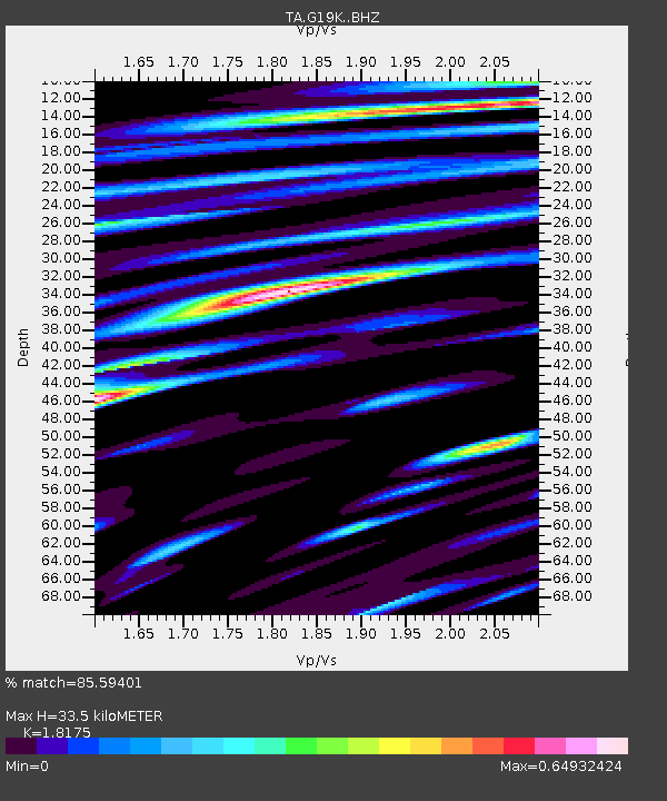
| Estimated Moho Depth: |
33.5 km |
| Estimated Crust Vp/Vs: |
1.82 |
| Assumed Crust Vp: |
6.577 km/s |
| Estimated Crust Vs: |
3.619 km/s |
| Estimated Crust Poisson's Ratio: |
0.28 |
|
| Radial Match: |
85.59401 % |
| Radial Bump: |
400 |
| Transverse Match: |
75.09348 % |
| Transverse Bump: |
400 |
| SOD ConfigId: |
13570011 |
| Insert Time: |
2019-04-28 20:03:02.884 +0000 |
| GWidth: |
2.5 |
| Max Bumps: |
400 |
| Tol: |
0.001 |
|

Signal To Noise
| Channel | StoN | STA | LTA |
| TA:G19K: :BHZ:20170920T14:40:06.175029Z | 10.562436 | 1.0559629E-6 | 9.997343E-8 |
| TA:G19K: :BHN:20170920T14:40:06.175029Z | 1.2341274 | 1.1962788E-7 | 9.693318E-8 |
| TA:G19K: :BHE:20170920T14:40:06.175029Z | 7.679364 | 6.664912E-7 | 8.6789896E-8 |
| Arrivals |
| Ps | 4.3 SECOND |
| PpPs | 14 SECOND |
| PsPs/PpSs | 18 SECOND |


