You are here: Home > Network List > TA - USArray Transportable Network (new EarthScope stations) Stations List
> Station K15K Wolf Creek Mountain, AK, USA > Earthquake Result Viewer
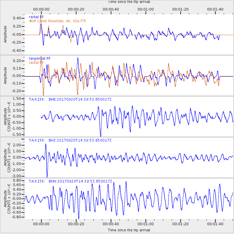
K15K Wolf Creek Mountain, AK, USA - Earthquake Result Viewer
*The percent match for this event was below the threshold and hence no stack was calculated.
| Earthquake location: |
Taiwan |
| Earthquake latitude/longitude: |
23.3/121.8 |
| Earthquake time(UTC): |
2017/09/20 (263) 14:29:56 GMT |
| Earthquake Depth: |
22 km |
| Earthquake Magnitude: |
5.3 Mww |
| Earthquake Catalog/Contributor: |
NEIC PDE/us |
|
| Network: |
TA USArray Transportable Network (new EarthScope stations) |
| Station: |
K15K Wolf Creek Mountain, AK, USA |
| Lat/Lon: |
62.29 N/161.53 W |
| Elevation: |
346 m |
|
| Distance: |
63.5 deg |
| Az: |
30.553 deg |
| Baz: |
269.805 deg |
| Ray Param: |
$rayparam |
*The percent match for this event was below the threshold and hence was not used in the summary stack. |
|
| Radial Match: |
61.573383 % |
| Radial Bump: |
400 |
| Transverse Match: |
51.13859 % |
| Transverse Bump: |
362 |
| SOD ConfigId: |
13570011 |
| Insert Time: |
2019-04-28 20:03:38.037 +0000 |
| GWidth: |
2.5 |
| Max Bumps: |
400 |
| Tol: |
0.001 |
|
Signal To Noise
| Channel | StoN | STA | LTA |
| TA:K15K: :BHZ:20170920T14:39:53.850017Z | 4.878245 | 1.1294363E-6 | 2.3152515E-7 |
| TA:K15K: :BHN:20170920T14:39:53.850017Z | 1.0063757 | 1.4747792E-7 | 1.465436E-7 |
| TA:K15K: :BHE:20170920T14:39:53.850017Z | 3.80114 | 6.253209E-7 | 1.6450878E-7 |
| Arrivals |
| Ps | |
| PpPs | |
| PsPs/PpSs | |


