You are here: Home > Network List > TA - USArray Transportable Network (new EarthScope stations) Stations List
> Station N10A Dunphy, NV, USA > Earthquake Result Viewer
N10A Dunphy, NV, USA - Earthquake Result Viewer
| Earthquake location: |
Andreanof Islands, Aleutian Is. |
| Earthquake latitude/longitude: |
52.2/-178.7 |
| Earthquake time(UTC): |
2008/03/22 (082) 21:24:11 GMT |
| Earthquake Depth: |
132 km |
| Earthquake Magnitude: |
5.8 MB, 6.2 MW, 6.1 MW |
| Earthquake Catalog/Contributor: |
WHDF/NEIC |
|
| Network: |
TA USArray Transportable Network (new EarthScope stations) |
| Station: |
N10A Dunphy, NV, USA |
| Lat/Lon: |
40.72 N/116.51 W |
| Elevation: |
1392 m |
|
| Distance: |
43.1 deg |
| Az: |
79.804 deg |
| Baz: |
307.119 deg |
| Ray Param: |
0.07228216 |
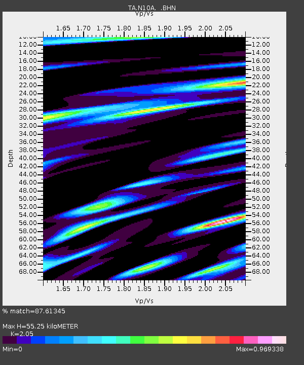
| Estimated Moho Depth: |
55.25 km |
| Estimated Crust Vp/Vs: |
2.05 |
| Assumed Crust Vp: |
6.276 km/s |
| Estimated Crust Vs: |
3.061 km/s |
| Estimated Crust Poisson's Ratio: |
0.34 |
|
| Radial Match: |
87.61345 % |
| Radial Bump: |
308 |
| Transverse Match: |
70.88861 % |
| Transverse Bump: |
400 |
| SOD ConfigId: |
2564 |
| Insert Time: |
2010-03-06 03:57:58.439 +0000 |
| GWidth: |
2.5 |
| Max Bumps: |
400 |
| Tol: |
0.001 |
|
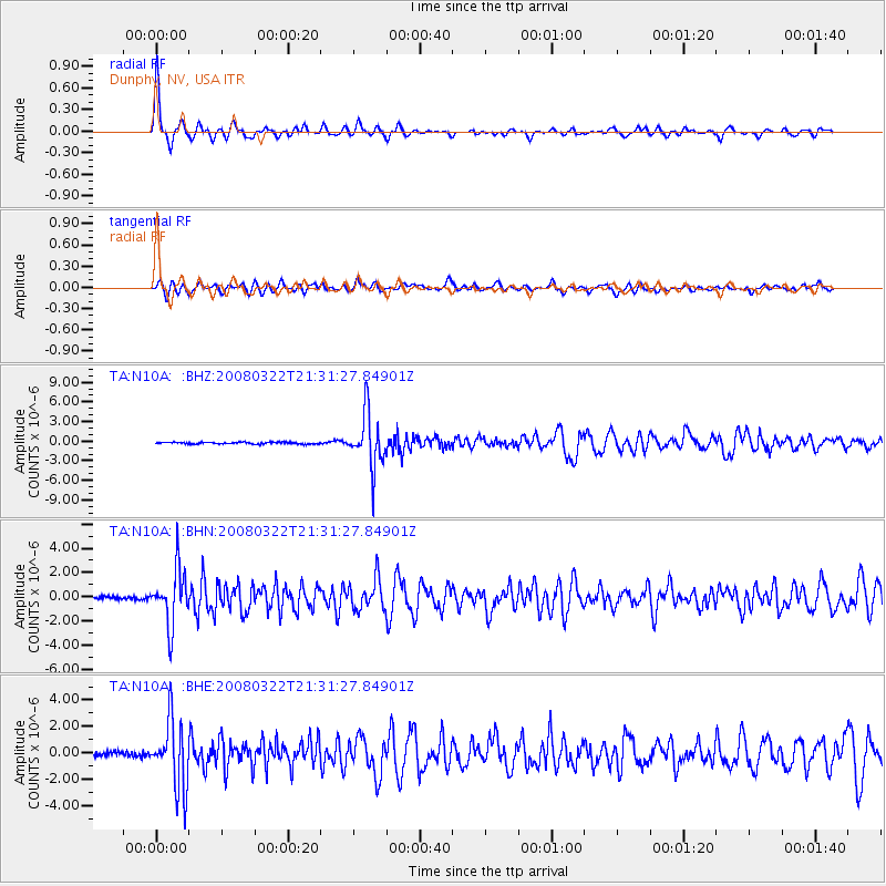
Signal To Noise
| Channel | StoN | STA | LTA |
| TA:N10A: :BHN:20080322T21:31:27.84901Z | 14.773829 | 2.2602944E-6 | 1.5299314E-7 |
| TA:N10A: :BHE:20080322T21:31:27.84901Z | 14.863655 | 2.569814E-6 | 1.7289246E-7 |
| TA:N10A: :BHZ:20080322T21:31:27.84901Z | 29.339384 | 4.076168E-6 | 1.3893161E-7 |
| Arrivals |
| Ps | 9.8 SECOND |
| PpPs | 25 SECOND |
| PsPs/PpSs | 35 SECOND |


