You are here: Home > Network List > TA - USArray Transportable Network (new EarthScope stations) Stations List
> Station P17K Kvichak River, AK, USA > Earthquake Result Viewer
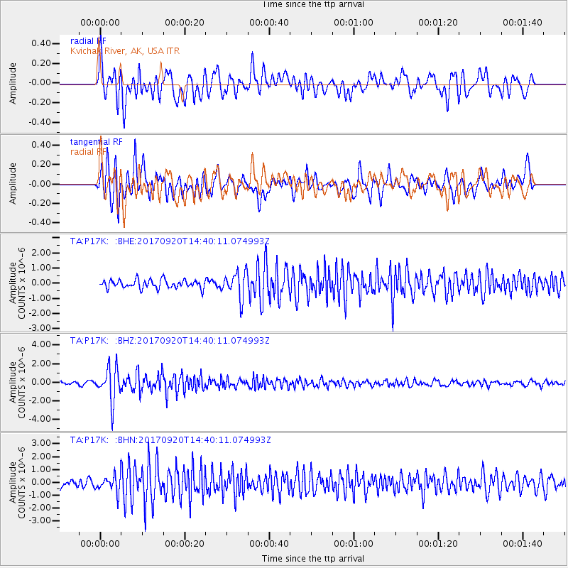
P17K Kvichak River, AK, USA - Earthquake Result Viewer
*The percent match for this event was below the threshold and hence no stack was calculated.
| Earthquake location: |
Taiwan |
| Earthquake latitude/longitude: |
23.3/121.8 |
| Earthquake time(UTC): |
2017/09/20 (263) 14:29:56 GMT |
| Earthquake Depth: |
22 km |
| Earthquake Magnitude: |
5.3 Mww |
| Earthquake Catalog/Contributor: |
NEIC PDE/us |
|
| Network: |
TA USArray Transportable Network (new EarthScope stations) |
| Station: |
P17K Kvichak River, AK, USA |
| Lat/Lon: |
59.20 N/156.44 W |
| Elevation: |
91 m |
|
| Distance: |
66.1 deg |
| Az: |
33.85 deg |
| Baz: |
275.646 deg |
| Ray Param: |
$rayparam |
*The percent match for this event was below the threshold and hence was not used in the summary stack. |
|
| Radial Match: |
77.98194 % |
| Radial Bump: |
400 |
| Transverse Match: |
78.58829 % |
| Transverse Bump: |
400 |
| SOD ConfigId: |
13570011 |
| Insert Time: |
2019-04-28 20:04:18.099 +0000 |
| GWidth: |
2.5 |
| Max Bumps: |
400 |
| Tol: |
0.001 |
|
Signal To Noise
| Channel | StoN | STA | LTA |
| TA:P17K: :BHZ:20170920T14:40:11.074993Z | 12.490994 | 1.8252002E-6 | 1.4612128E-7 |
| TA:P17K: :BHN:20170920T14:40:11.074993Z | 1.7403554 | 6.2411164E-7 | 3.5861163E-7 |
| TA:P17K: :BHE:20170920T14:40:11.074993Z | 3.1162426 | 8.677016E-7 | 2.7844482E-7 |
| Arrivals |
| Ps | |
| PpPs | |
| PsPs/PpSs | |


