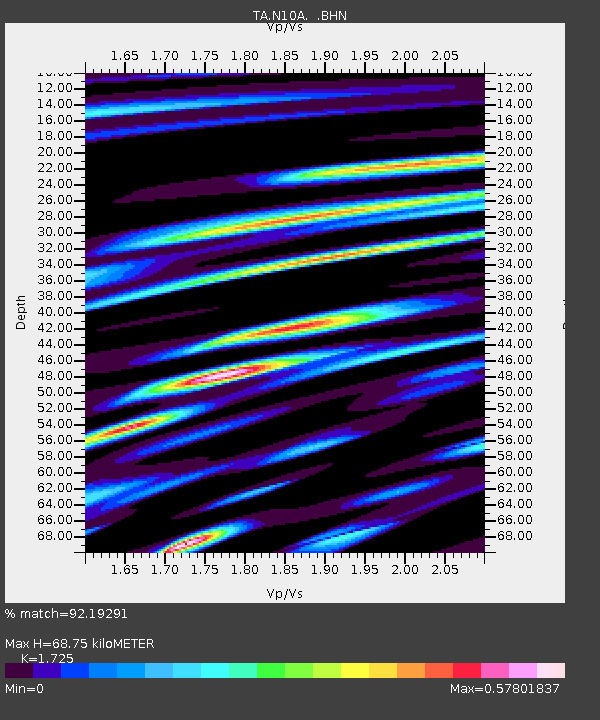
N10A Dunphy, NV, USA - Earthquake Result Viewer
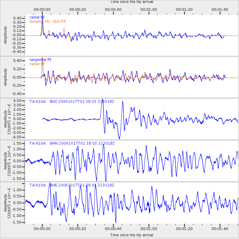
Earthquake location: New Britain Region, P.N.G.
Earthquake latitude/longitude: -5.9/151.0
Earthquake time(UTC): 2006/10/17 (290) 01:25:12 GMT
Earthquake Depth: 32 km
Earthquake Magnitude: 6.4 MB, 6.9 MS, 6.7 MW, 6.6 MW
Earthquake Catalog/Contributor: WHDF/NEIC
Network: TA USArray Transportable Network (new EarthScope stations)
Station: N10A Dunphy, NV, USA
Lat/Lon: 40.72 N/116.51 W
Elevation: 1392 m
Distance: 95.7 deg
Az: 49.74 deg
Baz: 267.174 deg
Ray Param: 0.040699977
Estimated Moho Depth: 68.75 km
Estimated Crust Vp/Vs: 1.73
Assumed Crust Vp: 6.276 km/s
Estimated Crust Vs: 3.638 km/s
Estimated Crust Poisson's Ratio: 0.25
Radial Match: 92.19291 %
Radial Bump: 400
Transverse Match: 90.48883 %
Transverse Bump: 400
SOD ConfigId: 2665
Insert Time: 2010-03-06 03:58:18.133 +0000
GWidth: 2.5
Max Bumps: 400
Tol: 0.001

Signal To Noise

ChannelStoNSTALTA
TA:N10A: :BHN:20061017T01:38:03.323018Z0.996372761.3864937E-71.3915411E-7
TA:N10A: :BHE:20061017T01:38:03.323018Z4.16768036.500962E-71.5598513E-7
TA:N10A: :BHZ:20061017T01:38:03.323018Z14.9074121.7539899E-61.17658914E-7
Arrivals
Ps8.1 SECOND
PpPs29 SECOND
PsPs/PpSs37 SECOND