You are here: Home > Network List > TA - USArray Transportable Network (new EarthScope stations) Stations List
> Station N10A Dunphy, NV, USA > Earthquake Result Viewer
N10A Dunphy, NV, USA - Earthquake Result Viewer

| Earthquake location: |
Fox Islands, Aleutian Islands |
| Earthquake latitude/longitude: |
54.0/-166.4 |
| Earthquake time(UTC): |
2006/09/01 (244) 12:04:22 GMT |
| Earthquake Depth: |
76 km |
| Earthquake Magnitude: |
5.8 MB, 5.9 MW |
| Earthquake Catalog/Contributor: |
WHDF/NEIC |
|
| Network: |
TA USArray Transportable Network (new EarthScope stations) |
| Station: |
N10A Dunphy, NV, USA |
| Lat/Lon: |
40.72 N/116.51 W |
| Elevation: |
1392 m |
|
| Distance: |
35.5 deg |
| Az: |
91.107 deg |
| Baz: |
309.002 deg |
| Ray Param: |
0.07693806 |
| Estimated Moho Depth: |
57.25 km |
| Estimated Crust Vp/Vs: |
1.66 |
| Assumed Crust Vp: |
6.276 km/s |
| Estimated Crust Vs: |
3.786 km/s |
| Estimated Crust Poisson's Ratio: |
0.21 |
|
| Radial Match: |
83.63917 % |
| Radial Bump: |
400 |
| Transverse Match: |
72.99622 % |
| Transverse Bump: |
400 |
| SOD ConfigId: |
2665 |
| Insert Time: |
2010-03-06 03:58:27.503 +0000 |
| GWidth: |
2.5 |
| Max Bumps: |
400 |
| Tol: |
0.001 |
|
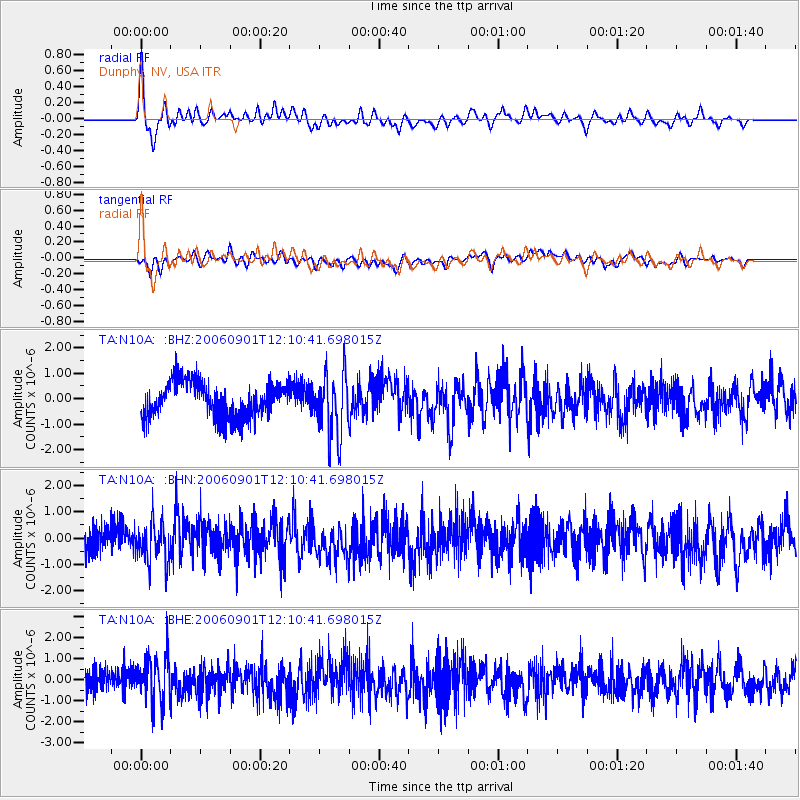
Signal To Noise
| Channel | StoN | STA | LTA |
| TA:N10A: :BHN:20060901T12:10:41.698015Z | 1.2374508 | 7.376179E-7 | 5.9607856E-7 |
| TA:N10A: :BHE:20060901T12:10:41.698015Z | 1.9772317 | 1.0729934E-6 | 5.4267457E-7 |
| TA:N10A: :BHZ:20060901T12:10:41.698015Z | 1.8292515 | 1.2649642E-6 | 6.915201E-7 |
| Arrivals |
| Ps | 6.5 SECOND |
| PpPs | 22 SECOND |
| PsPs/PpSs | 29 SECOND |


