You are here: Home > Network List > AK - Alaska Regional Network Stations List
> Station CUT Chulitna, AK, USA > Earthquake Result Viewer
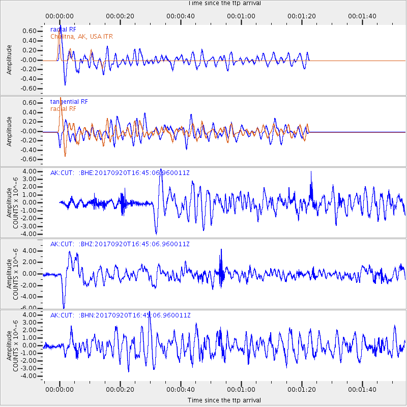
CUT Chulitna, AK, USA - Earthquake Result Viewer
*The percent match for this event was below the threshold and hence no stack was calculated.
| Earthquake location: |
Off East Coast Of Honshu, Japan |
| Earthquake latitude/longitude: |
38.0/144.7 |
| Earthquake time(UTC): |
2017/09/20 (263) 16:37:16 GMT |
| Earthquake Depth: |
10 km |
| Earthquake Magnitude: |
6.1 Mww |
| Earthquake Catalog/Contributor: |
NEIC PDE/us |
|
| Network: |
AK Alaska Regional Network |
| Station: |
CUT Chulitna, AK, USA |
| Lat/Lon: |
62.41 N/150.26 W |
| Elevation: |
574 m |
|
| Distance: |
45.8 deg |
| Az: |
36.102 deg |
| Baz: |
269.247 deg |
| Ray Param: |
$rayparam |
*The percent match for this event was below the threshold and hence was not used in the summary stack. |
|
| Radial Match: |
77.44348 % |
| Radial Bump: |
400 |
| Transverse Match: |
65.7174 % |
| Transverse Bump: |
400 |
| SOD ConfigId: |
13570011 |
| Insert Time: |
2019-04-28 20:06:20.291 +0000 |
| GWidth: |
2.5 |
| Max Bumps: |
400 |
| Tol: |
0.001 |
|
Signal To Noise
| Channel | StoN | STA | LTA |
| AK:CUT: :BHZ:20170920T16:45:06.960011Z | 5.0500937 | 2.570452E-6 | 5.089909E-7 |
| AK:CUT: :BHN:20170920T16:45:06.960011Z | 2.228045 | 8.290806E-7 | 3.7211126E-7 |
| AK:CUT: :BHE:20170920T16:45:06.960011Z | 5.7916374 | 2.183646E-6 | 3.7703433E-7 |
| Arrivals |
| Ps | |
| PpPs | |
| PsPs/PpSs | |


