You are here: Home > Network List > CI - Caltech Regional Seismic Network Stations List
> Station BAR Barrett, Tecate, CA, USA > Earthquake Result Viewer
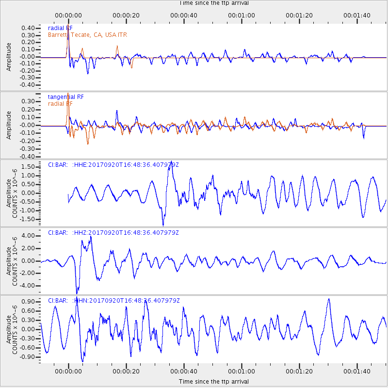
BAR Barrett, Tecate, CA, USA - Earthquake Result Viewer
*The percent match for this event was below the threshold and hence no stack was calculated.
| Earthquake location: |
Off East Coast Of Honshu, Japan |
| Earthquake latitude/longitude: |
38.0/144.7 |
| Earthquake time(UTC): |
2017/09/20 (263) 16:37:16 GMT |
| Earthquake Depth: |
10 km |
| Earthquake Magnitude: |
6.1 Mww |
| Earthquake Catalog/Contributor: |
NEIC PDE/us |
|
| Network: |
CI Caltech Regional Seismic Network |
| Station: |
BAR Barrett, Tecate, CA, USA |
| Lat/Lon: |
32.68 N/116.67 W |
| Elevation: |
521 m |
|
| Distance: |
76.8 deg |
| Az: |
58.925 deg |
| Baz: |
306.628 deg |
| Ray Param: |
$rayparam |
*The percent match for this event was below the threshold and hence was not used in the summary stack. |
|
| Radial Match: |
69.54387 % |
| Radial Bump: |
358 |
| Transverse Match: |
79.95601 % |
| Transverse Bump: |
400 |
| SOD ConfigId: |
13570011 |
| Insert Time: |
2019-04-28 20:09:06.312 +0000 |
| GWidth: |
2.5 |
| Max Bumps: |
400 |
| Tol: |
0.001 |
|
Signal To Noise
| Channel | StoN | STA | LTA |
| CI:BAR: :HHZ:20170920T16:48:36.407979Z | 7.024505 | 2.310879E-6 | 3.289739E-7 |
| CI:BAR: :HHN:20170920T16:48:36.407979Z | 1.4804125 | 5.370527E-7 | 3.6277234E-7 |
| CI:BAR: :HHE:20170920T16:48:36.407979Z | 3.5048385 | 9.074471E-7 | 2.5891268E-7 |
| Arrivals |
| Ps | |
| PpPs | |
| PsPs/PpSs | |


