You are here: Home > Network List > TA - USArray Transportable Network (new EarthScope stations) Stations List
> Station I05A Bend, OR, USA > Earthquake Result Viewer
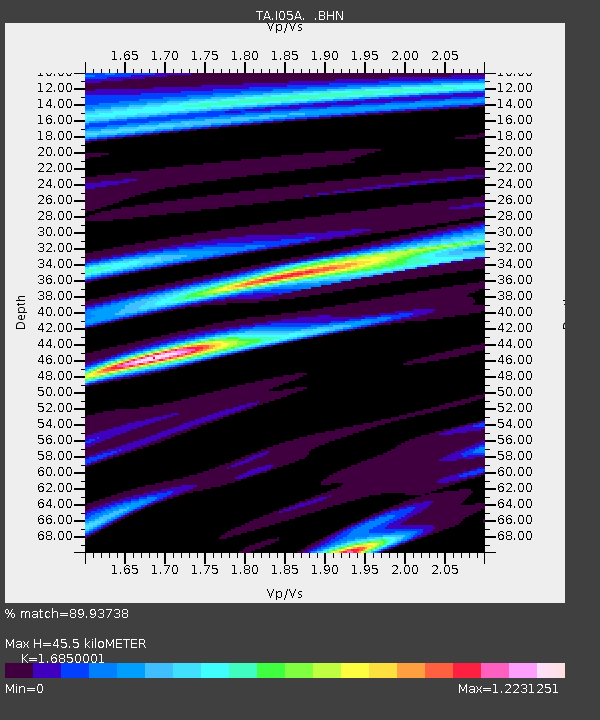
I05A Bend, OR, USA - Earthquake Result Viewer
| Earthquake location: |
Peru-Ecuador Border Region |
| Earthquake latitude/longitude: |
-2.3/-77.8 |
| Earthquake time(UTC): |
2007/11/16 (320) 03:13:00 GMT |
| Earthquake Depth: |
123 km |
| Earthquake Magnitude: |
6.3 MB, 6.8 MW, 6.7 MW |
| Earthquake Catalog/Contributor: |
WHDF/NEIC |
|
| Network: |
TA USArray Transportable Network (new EarthScope stations) |
| Station: |
I05A Bend, OR, USA |
| Lat/Lon: |
44.16 N/121.27 W |
| Elevation: |
1011 m |
|
| Distance: |
60.4 deg |
| Az: |
325.305 deg |
| Baz: |
127.79 deg |
| Ray Param: |
0.061212186 |
| Estimated Moho Depth: |
45.5 km |
| Estimated Crust Vp/Vs: |
1.69 |
| Assumed Crust Vp: |
6.597 km/s |
| Estimated Crust Vs: |
3.915 km/s |
| Estimated Crust Poisson's Ratio: |
0.23 |
|
| Radial Match: |
89.93738 % |
| Radial Bump: |
400 |
| Transverse Match: |
78.650566 % |
| Transverse Bump: |
400 |
| SOD ConfigId: |
2564 |
| Insert Time: |
2010-03-06 03:59:24.439 +0000 |
| GWidth: |
2.5 |
| Max Bumps: |
400 |
| Tol: |
0.001 |
|

Signal To Noise
| Channel | StoN | STA | LTA |
| TA:I05A: :BHN:20071116T03:22:25.575017Z | 0.6047743 | 7.838491E-7 | 1.2961019E-6 |
| TA:I05A: :BHE:20071116T03:22:25.575017Z | 1.6364654 | 6.9222943E-7 | 4.230028E-7 |
| TA:I05A: :BHZ:20071116T03:22:25.575017Z | 3.0224805 | 1.8499293E-6 | 6.120567E-7 |
| Arrivals |
| Ps | 5.0 SECOND |
| PpPs | 18 SECOND |
| PsPs/PpSs | 23 SECOND |


