You are here: Home > Network List > TA - USArray Transportable Network (new EarthScope stations) Stations List
> Station I05A Bend, OR, USA > Earthquake Result Viewer
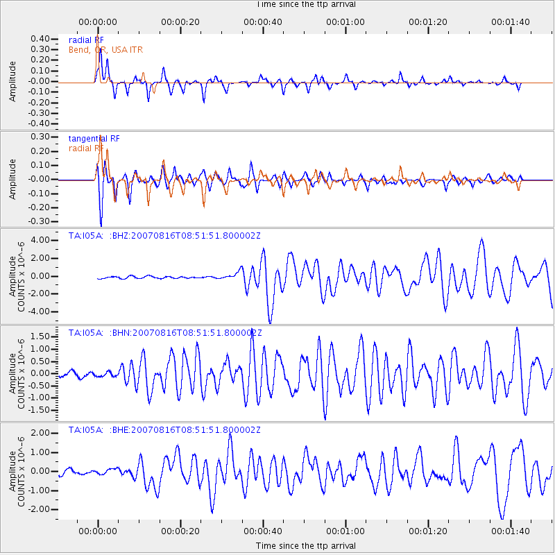
I05A Bend, OR, USA - Earthquake Result Viewer

| Earthquake location: |
Solomon Islands |
| Earthquake latitude/longitude: |
-9.8/159.5 |
| Earthquake time(UTC): |
2007/08/16 (228) 08:39:27 GMT |
| Earthquake Depth: |
10 km |
| Earthquake Magnitude: |
6.1 MB, 6.7 MS, 6.4 MW |
| Earthquake Catalog/Contributor: |
WHDF/NEIC |
|
| Network: |
TA USArray Transportable Network (new EarthScope stations) |
| Station: |
I05A Bend, OR, USA |
| Lat/Lon: |
44.16 N/121.27 W |
| Elevation: |
1011 m |
|
| Distance: |
89.2 deg |
| Az: |
45.006 deg |
| Baz: |
255.55 deg |
| Ray Param: |
0.042039633 |
| Estimated Moho Depth: |
26.0 km |
| Estimated Crust Vp/Vs: |
1.60 |
| Assumed Crust Vp: |
6.597 km/s |
| Estimated Crust Vs: |
4.123 km/s |
| Estimated Crust Poisson's Ratio: |
0.18 |
|
| Radial Match: |
92.18046 % |
| Radial Bump: |
325 |
| Transverse Match: |
91.24329 % |
| Transverse Bump: |
368 |
| SOD ConfigId: |
2564 |
| Insert Time: |
2010-03-06 03:59:37.394 +0000 |
| GWidth: |
2.5 |
| Max Bumps: |
400 |
| Tol: |
0.001 |
|
Signal To Noise
| Channel | StoN | STA | LTA |
| TA:I05A: :BHN:20070816T08:51:51.800002Z | 0.83968735 | 8.583865E-8 | 1.0222692E-7 |
| TA:I05A: :BHE:20070816T08:51:51.800002Z | 1.0015641 | 1.3531631E-7 | 1.3510498E-7 |
| TA:I05A: :BHZ:20070816T08:51:51.800002Z | 3.9963953 | 4.5775226E-7 | 1.1454129E-7 |
| Arrivals |
| Ps | 2.4 SECOND |
| PpPs | 10.0 SECOND |
| PsPs/PpSs | 12 SECOND |


