You are here: Home > Network List > TA - USArray Transportable Network (new EarthScope stations) Stations List
> Station I05A Bend, OR, USA > Earthquake Result Viewer
I05A Bend, OR, USA - Earthquake Result Viewer
| Earthquake location: |
Solomon Islands |
| Earthquake latitude/longitude: |
-8.5/157.0 |
| Earthquake time(UTC): |
2007/04/01 (091) 20:39:56 GMT |
| Earthquake Depth: |
10 km |
| Earthquake Magnitude: |
6.8 MB, 7.9 MS, 8.1 MW, 7.7 ME |
| Earthquake Catalog/Contributor: |
WHDF/NEIC |
|
| Network: |
TA USArray Transportable Network (new EarthScope stations) |
| Station: |
I05A Bend, OR, USA |
| Lat/Lon: |
44.16 N/121.27 W |
| Elevation: |
1011 m |
|
| Distance: |
89.9 deg |
| Az: |
45.409 deg |
| Baz: |
258.201 deg |
| Ray Param: |
0.041710522 |
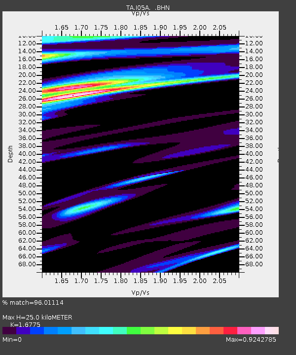
| Estimated Moho Depth: |
25.0 km |
| Estimated Crust Vp/Vs: |
1.68 |
| Assumed Crust Vp: |
6.597 km/s |
| Estimated Crust Vs: |
3.933 km/s |
| Estimated Crust Poisson's Ratio: |
0.22 |
|
| Radial Match: |
96.01114 % |
| Radial Bump: |
334 |
| Transverse Match: |
92.0054 % |
| Transverse Bump: |
400 |
| SOD ConfigId: |
2564 |
| Insert Time: |
2010-03-06 03:59:59.305 +0000 |
| GWidth: |
2.5 |
| Max Bumps: |
400 |
| Tol: |
0.001 |
|

Signal To Noise
| Channel | StoN | STA | LTA |
| TA:I05A: :BHN:20070401T20:52:24.02502Z | 1.6621101 | 4.856528E-7 | 2.921905E-7 |
| TA:I05A: :BHE:20070401T20:52:24.02502Z | 1.8364315 | 6.0640156E-7 | 3.3020646E-7 |
| TA:I05A: :BHZ:20070401T20:52:24.02502Z | 7.050386 | 1.604903E-6 | 2.2763336E-7 |
| Arrivals |
| Ps | 2.6 SECOND |
| PpPs | 9.9 SECOND |
| PsPs/PpSs | 13 SECOND |


