You are here: Home > Network List > GS - US Geological Survey Networks Stations List
> Station OK051 E0350 and S34600 Roads, Ralston, OK > Earthquake Result Viewer
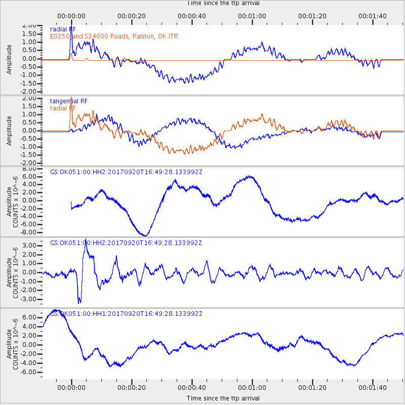
OK051 E0350 and S34600 Roads, Ralston, OK - Earthquake Result Viewer
*The percent match for this event was below the threshold and hence no stack was calculated.
| Earthquake location: |
Off East Coast Of Honshu, Japan |
| Earthquake latitude/longitude: |
38.0/144.7 |
| Earthquake time(UTC): |
2017/09/20 (263) 16:37:16 GMT |
| Earthquake Depth: |
10 km |
| Earthquake Magnitude: |
6.1 Mww |
| Earthquake Catalog/Contributor: |
NEIC PDE/us |
|
| Network: |
GS US Geological Survey Networks |
| Station: |
OK051 E0350 and S34600 Roads, Ralston, OK |
| Lat/Lon: |
36.51 N/96.84 W |
| Elevation: |
263 m |
|
| Distance: |
86.6 deg |
| Az: |
45.182 deg |
| Baz: |
315.917 deg |
| Ray Param: |
$rayparam |
*The percent match for this event was below the threshold and hence was not used in the summary stack. |
|
| Radial Match: |
27.687286 % |
| Radial Bump: |
400 |
| Transverse Match: |
64.60391 % |
| Transverse Bump: |
400 |
| SOD ConfigId: |
13570011 |
| Insert Time: |
2019-04-28 20:11:26.110 +0000 |
| GWidth: |
2.5 |
| Max Bumps: |
400 |
| Tol: |
0.001 |
|
Signal To Noise
| Channel | StoN | STA | LTA |
| GS:OK051:00:HHZ:20170920T16:49:28.133992Z | 9.3407135 | 1.8839232E-6 | 2.0168943E-7 |
| GS:OK051:00:HH1:20170920T16:49:28.133992Z | 0.6976447 | 2.3159785E-6 | 3.3197105E-6 |
| GS:OK051:00:HH2:20170920T16:49:28.133992Z | 1.3807654 | 4.5712864E-6 | 3.31069E-6 |
| Arrivals |
| Ps | |
| PpPs | |
| PsPs/PpSs | |


