You are here: Home > Network List > TA - USArray Transportable Network (new EarthScope stations) Stations List
> Station I05A Bend, OR, USA > Earthquake Result Viewer
I05A Bend, OR, USA - Earthquake Result Viewer
| Earthquake location: |
New Ireland Region, P.N.G. |
| Earthquake latitude/longitude: |
-4.5/153.5 |
| Earthquake time(UTC): |
2005/09/09 (252) 07:26:43 GMT |
| Earthquake Depth: |
90 km |
| Earthquake Magnitude: |
6.3 MB, 7.7 MW, 7.5 MW |
| Earthquake Catalog/Contributor: |
WHDF/NEIC |
|
| Network: |
TA USArray Transportable Network (new EarthScope stations) |
| Station: |
I05A Bend, OR, USA |
| Lat/Lon: |
44.16 N/121.27 W |
| Elevation: |
1011 m |
|
| Distance: |
89.7 deg |
| Az: |
45.827 deg |
| Baz: |
263.466 deg |
| Ray Param: |
0.041706763 |
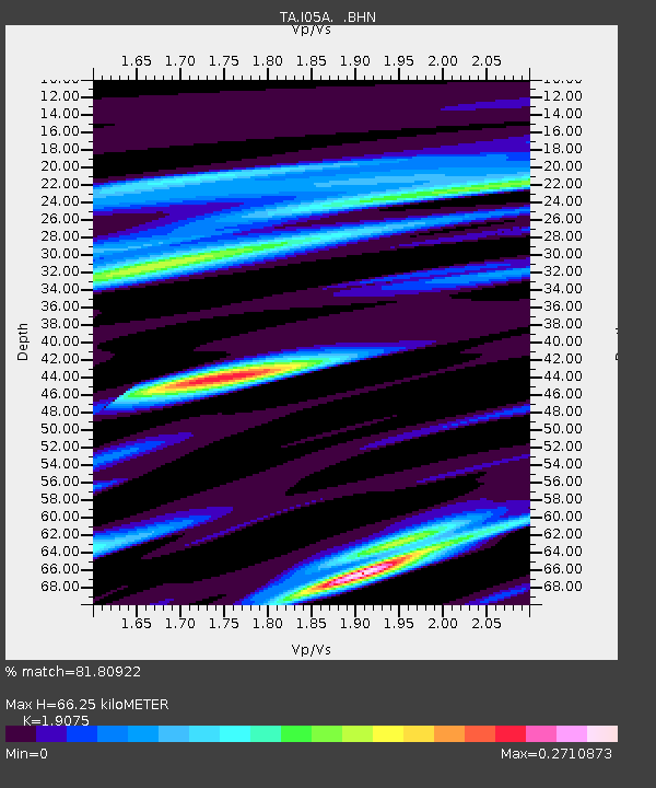
| Estimated Moho Depth: |
66.25 km |
| Estimated Crust Vp/Vs: |
1.91 |
| Assumed Crust Vp: |
6.597 km/s |
| Estimated Crust Vs: |
3.459 km/s |
| Estimated Crust Poisson's Ratio: |
0.31 |
|
| Radial Match: |
81.80922 % |
| Radial Bump: |
335 |
| Transverse Match: |
74.78093 % |
| Transverse Bump: |
400 |
| SOD ConfigId: |
132717 |
| Insert Time: |
2010-03-06 04:00:11.010 +0000 |
| GWidth: |
2.5 |
| Max Bumps: |
400 |
| Tol: |
0.001 |
|
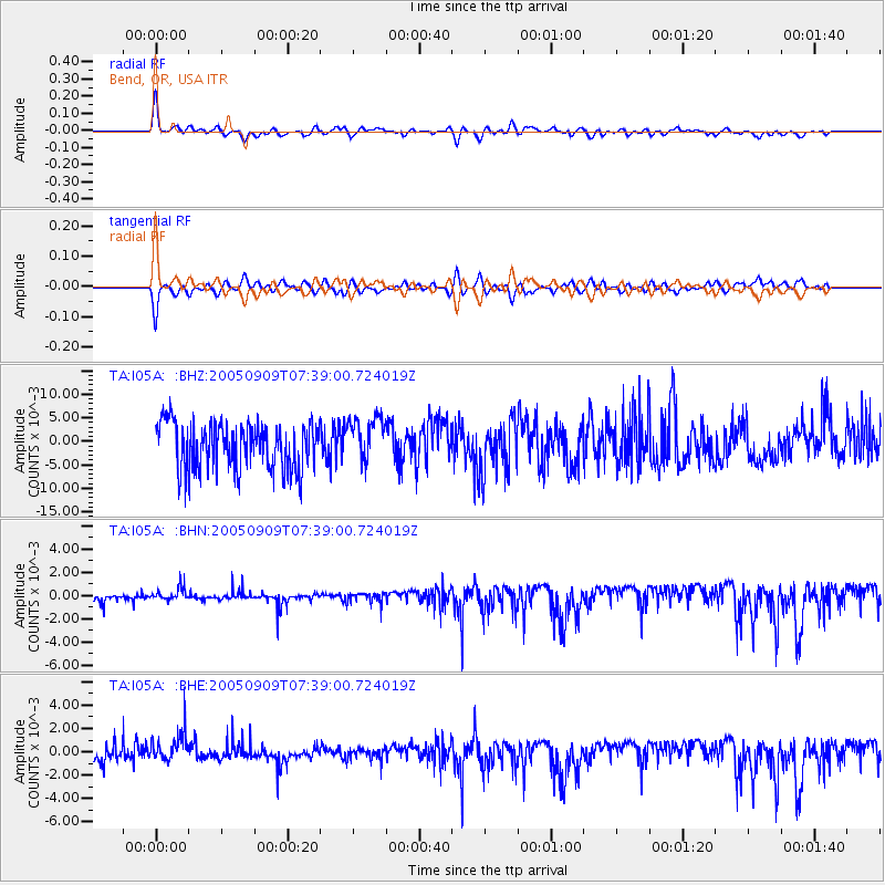
Signal To Noise
| Channel | StoN | STA | LTA |
| TA:I05A: :BHN:20050909T07:39:00.724019Z | 1.2043047 | 5.3689064E-4 | 4.4580962E-4 |
| TA:I05A: :BHE:20050909T07:39:00.724019Z | 1.6357408 | 0.0011779557 | 7.2013587E-4 |
| TA:I05A: :BHZ:20050909T07:39:00.724019Z | 0.98370546 | 0.00492025 | 0.0050017512 |
| Arrivals |
| Ps | 9.3 SECOND |
| PpPs | 29 SECOND |
| PsPs/PpSs | 38 SECOND |


