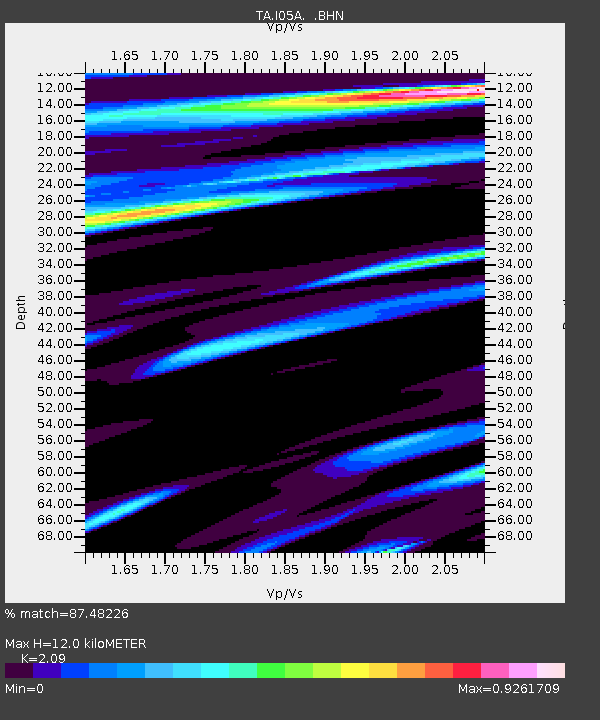
I05A Bend, OR, USA - Earthquake Result Viewer
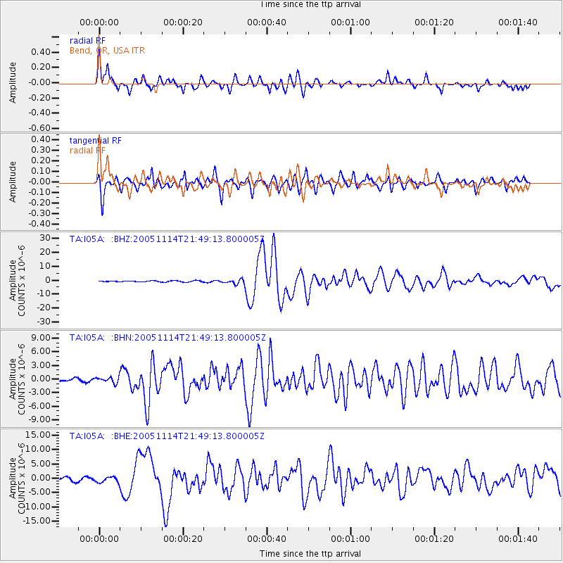
Earthquake location: Off East Coast Of Honshu, Japan
Earthquake latitude/longitude: 38.1/144.9
Earthquake time(UTC): 2005/11/14 (318) 21:38:51 GMT
Earthquake Depth: 11 km
Earthquake Magnitude: 6.7 MB, 6.8 MS, 7.0 MW, 6.9 MW
Earthquake Catalog/Contributor: WHDF/NEIC
Network: TA USArray Transportable Network (new EarthScope stations)
Station: I05A Bend, OR, USA
Lat/Lon: 44.16 N/121.27 W
Elevation: 1011 m
Distance: 67.1 deg
Az: 51.203 deg
Baz: 301.32 deg
Ray Param: 0.057157297
Estimated Moho Depth: 12.0 km
Estimated Crust Vp/Vs: 2.09
Assumed Crust Vp: 6.597 km/s
Estimated Crust Vs: 3.157 km/s
Estimated Crust Poisson's Ratio: 0.35
Radial Match: 87.48226 %
Radial Bump: 400
Transverse Match: 87.45958 %
Transverse Bump: 400
SOD ConfigId: 2448
Insert Time: 2010-03-06 04:00:15.818 +0000
GWidth: 2.5
Max Bumps: 400
Tol: 0.001

Signal To Noise

ChannelStoNSTALTA
TA:I05A: :BHN:20051114T21:49:13.800005Z1.46689096.293286E-74.2902212E-7
TA:I05A: :BHE:20051114T21:49:13.800005Z1.53044069.926353E-76.4859444E-7
TA:I05A: :BHZ:20051114T21:49:13.800005Z4.07400941.7951144E-64.4062597E-7
Arrivals
Ps2.1 SECOND
PpPs5.4 SECOND
PsPs/PpSs7.5 SECOND