You are here: Home > Network List > TA - USArray Transportable Network (new EarthScope stations) Stations List
> Station I05A Bend, OR, USA > Earthquake Result Viewer
I05A Bend, OR, USA - Earthquake Result Viewer
| Earthquake location: |
Chile-Argentina Border Region |
| Earthquake latitude/longitude: |
-24.4/-67.0 |
| Earthquake time(UTC): |
2006/08/25 (237) 00:44:46 GMT |
| Earthquake Depth: |
184 km |
| Earthquake Magnitude: |
5.9 MB, 6.6 MW, 6.6 MW |
| Earthquake Catalog/Contributor: |
WHDF/NEIC |
|
| Network: |
TA USArray Transportable Network (new EarthScope stations) |
| Station: |
I05A Bend, OR, USA |
| Lat/Lon: |
44.16 N/121.27 W |
| Elevation: |
1011 m |
|
| Distance: |
84.4 deg |
| Az: |
324.066 deg |
| Baz: |
131.979 deg |
| Ray Param: |
0.04509486 |
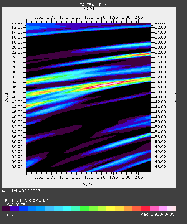
| Estimated Moho Depth: |
34.75 km |
| Estimated Crust Vp/Vs: |
1.92 |
| Assumed Crust Vp: |
6.597 km/s |
| Estimated Crust Vs: |
3.441 km/s |
| Estimated Crust Poisson's Ratio: |
0.31 |
|
| Radial Match: |
92.18277 % |
| Radial Bump: |
400 |
| Transverse Match: |
78.19645 % |
| Transverse Bump: |
400 |
| SOD ConfigId: |
2665 |
| Insert Time: |
2010-03-06 04:00:23.327 +0000 |
| GWidth: |
2.5 |
| Max Bumps: |
400 |
| Tol: |
0.001 |
|

Signal To Noise
| Channel | StoN | STA | LTA |
| TA:I05A: :BHN:20060825T00:56:26.424019Z | 5.186971 | 6.2649315E-7 | 1.2078208E-7 |
| TA:I05A: :BHE:20060825T00:56:26.424019Z | 4.735489 | 6.4796734E-7 | 1.3683218E-7 |
| TA:I05A: :BHZ:20060825T00:56:26.424019Z | 16.135761 | 2.4271476E-6 | 1.5042039E-7 |
| Arrivals |
| Ps | 4.9 SECOND |
| PpPs | 15 SECOND |
| PsPs/PpSs | 20 SECOND |


