You are here: Home > Network List > TA - USArray Transportable Network (new EarthScope stations) Stations List
> Station I05A Bend, OR, USA > Earthquake Result Viewer
I05A Bend, OR, USA - Earthquake Result Viewer
| Earthquake location: |
Kermadec Islands Region |
| Earthquake latitude/longitude: |
-31.8/-179.3 |
| Earthquake time(UTC): |
2006/05/16 (136) 10:39:23 GMT |
| Earthquake Depth: |
152 km |
| Earthquake Magnitude: |
6.8 MB, 7.4 MW, 7.4 MW |
| Earthquake Catalog/Contributor: |
WHDF/NEIC |
|
| Network: |
TA USArray Transportable Network (new EarthScope stations) |
| Station: |
I05A Bend, OR, USA |
| Lat/Lon: |
44.16 N/121.27 W |
| Elevation: |
1011 m |
|
| Distance: |
92.3 deg |
| Az: |
37.67 deg |
| Baz: |
226.317 deg |
| Ray Param: |
0.041405577 |
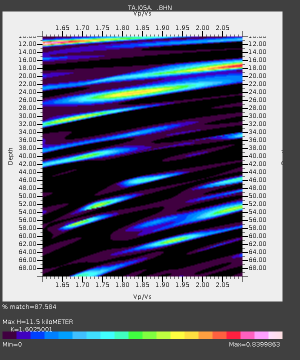
| Estimated Moho Depth: |
11.5 km |
| Estimated Crust Vp/Vs: |
1.60 |
| Assumed Crust Vp: |
6.597 km/s |
| Estimated Crust Vs: |
4.117 km/s |
| Estimated Crust Poisson's Ratio: |
0.18 |
|
| Radial Match: |
87.584 % |
| Radial Bump: |
400 |
| Transverse Match: |
86.996796 % |
| Transverse Bump: |
400 |
| SOD ConfigId: |
2669 |
| Insert Time: |
2010-03-06 04:00:28.432 +0000 |
| GWidth: |
2.5 |
| Max Bumps: |
400 |
| Tol: |
0.001 |
|
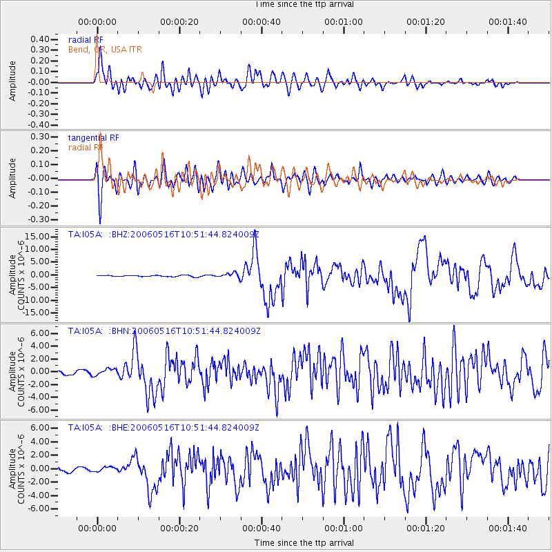
Signal To Noise
| Channel | StoN | STA | LTA |
| TA:I05A: :BHN:20060516T10:51:44.824009Z | 2.0547764 | 5.280578E-7 | 2.5699038E-7 |
| TA:I05A: :BHE:20060516T10:51:44.824009Z | 0.8216576 | 3.4730482E-7 | 4.22688E-7 |
| TA:I05A: :BHZ:20060516T10:51:44.824009Z | 3.8676543 | 9.899649E-7 | 2.5596E-7 |
| Arrivals |
| Ps | 1.1 SECOND |
| PpPs | 4.4 SECOND |
| PsPs/PpSs | 5.5 SECOND |


