You are here: Home > Network List > TA - USArray Transportable Network (new EarthScope stations) Stations List
> Station O04C Chester, CA, USA > Earthquake Result Viewer
O04C Chester, CA, USA - Earthquake Result Viewer
| Earthquake location: |
Tonga Islands |
| Earthquake latitude/longitude: |
-17.5/-174.3 |
| Earthquake time(UTC): |
2007/08/26 (238) 12:37:31 GMT |
| Earthquake Depth: |
127 km |
| Earthquake Magnitude: |
5.9 MB, 6.1 MW |
| Earthquake Catalog/Contributor: |
WHDF/NEIC |
|
| Network: |
TA USArray Transportable Network (new EarthScope stations) |
| Station: |
O04C Chester, CA, USA |
| Lat/Lon: |
40.32 N/121.09 W |
| Elevation: |
1513 m |
|
| Distance: |
75.8 deg |
| Az: |
39.182 deg |
| Baz: |
232.068 deg |
| Ray Param: |
0.051080745 |
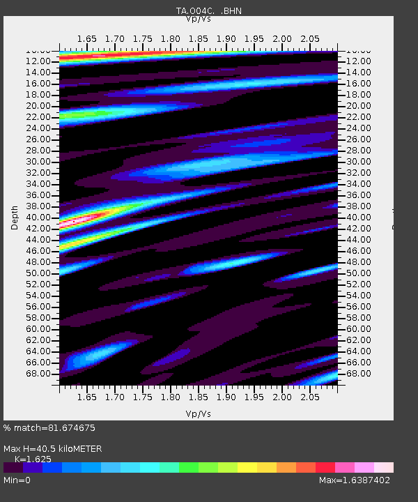
| Estimated Moho Depth: |
40.5 km |
| Estimated Crust Vp/Vs: |
1.62 |
| Assumed Crust Vp: |
6.566 km/s |
| Estimated Crust Vs: |
4.041 km/s |
| Estimated Crust Poisson's Ratio: |
0.20 |
|
| Radial Match: |
81.674675 % |
| Radial Bump: |
382 |
| Transverse Match: |
80.82232 % |
| Transverse Bump: |
400 |
| SOD ConfigId: |
2564 |
| Insert Time: |
2010-03-06 04:01:00.011 +0000 |
| GWidth: |
2.5 |
| Max Bumps: |
400 |
| Tol: |
0.001 |
|

Signal To Noise
| Channel | StoN | STA | LTA |
| TA:O04C: :BHN:20070826T12:48:32.499021Z | 4.80286 | 3.099117E-7 | 6.45265E-8 |
| TA:O04C: :BHE:20070826T12:48:32.499021Z | 3.1744528 | 2.577597E-7 | 8.119815E-8 |
| TA:O04C: :BHZ:20070826T12:48:32.499021Z | 15.10584 | 1.0406884E-6 | 6.8893115E-8 |
| Arrivals |
| Ps | 4.0 SECOND |
| PpPs | 16 SECOND |
| PsPs/PpSs | 20 SECOND |


