You are here: Home > Network List > TA - USArray Transportable Network (new EarthScope stations) Stations List
> Station O04C Chester, CA, USA > Earthquake Result Viewer
O04C Chester, CA, USA - Earthquake Result Viewer
| Earthquake location: |
Andreanof Islands, Aleutian Is. |
| Earthquake latitude/longitude: |
50.2/-177.6 |
| Earthquake time(UTC): |
2007/08/16 (228) 04:03:03 GMT |
| Earthquake Depth: |
15 km |
| Earthquake Magnitude: |
5.8 MB |
| Earthquake Catalog/Contributor: |
WHDF/NEIC |
|
| Network: |
TA USArray Transportable Network (new EarthScope stations) |
| Station: |
O04C Chester, CA, USA |
| Lat/Lon: |
40.32 N/121.09 W |
| Elevation: |
1513 m |
|
| Distance: |
40.1 deg |
| Az: |
81.95 deg |
| Baz: |
303.748 deg |
| Ray Param: |
0.07459163 |
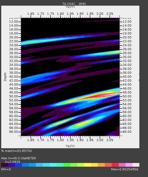
| Estimated Moho Depth: |
48.0 km |
| Estimated Crust Vp/Vs: |
2.09 |
| Assumed Crust Vp: |
6.566 km/s |
| Estimated Crust Vs: |
3.138 km/s |
| Estimated Crust Poisson's Ratio: |
0.35 |
|
| Radial Match: |
83.95704 % |
| Radial Bump: |
400 |
| Transverse Match: |
70.06077 % |
| Transverse Bump: |
400 |
| SOD ConfigId: |
2564 |
| Insert Time: |
2010-03-06 04:01:03.548 +0000 |
| GWidth: |
2.5 |
| Max Bumps: |
400 |
| Tol: |
0.001 |
|

Signal To Noise
| Channel | StoN | STA | LTA |
| TA:O04C: :BHN:20070816T04:10:07.375Z | 2.778978 | 4.9262013E-7 | 1.7726666E-7 |
| TA:O04C: :BHE:20070816T04:10:07.375Z | 2.7500186 | 7.132639E-7 | 2.593669E-7 |
| TA:O04C: :BHZ:20070816T04:10:07.375Z | 3.5924582 | 1.1893445E-6 | 3.3106704E-7 |
| Arrivals |
| Ps | 8.5 SECOND |
| PpPs | 21 SECOND |
| PsPs/PpSs | 30 SECOND |


