You are here: Home > Network List > TA - USArray Transportable Network (new EarthScope stations) Stations List
> Station O04C Chester, CA, USA > Earthquake Result Viewer
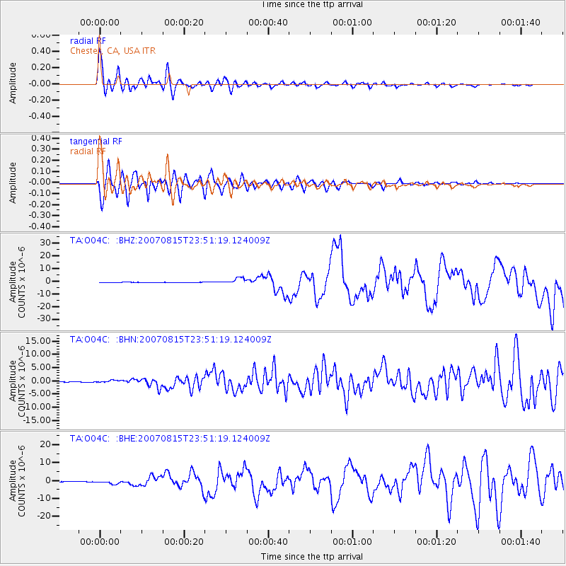
O04C Chester, CA, USA - Earthquake Result Viewer

| Earthquake location: |
Near Coast Of Peru |
| Earthquake latitude/longitude: |
-13.4/-76.6 |
| Earthquake time(UTC): |
2007/08/15 (227) 23:40:57 GMT |
| Earthquake Depth: |
39 km |
| Earthquake Magnitude: |
6.7 MB, 7.9 MS, 8.0 MW, 7.5 ME |
| Earthquake Catalog/Contributor: |
WHDF/NEIC |
|
| Network: |
TA USArray Transportable Network (new EarthScope stations) |
| Station: |
O04C Chester, CA, USA |
| Lat/Lon: |
40.32 N/121.09 W |
| Elevation: |
1513 m |
|
| Distance: |
67.5 deg |
| Az: |
324.559 deg |
| Baz: |
132.434 deg |
| Ray Param: |
0.056844495 |
| Estimated Moho Depth: |
30.25 km |
| Estimated Crust Vp/Vs: |
1.95 |
| Assumed Crust Vp: |
6.566 km/s |
| Estimated Crust Vs: |
3.376 km/s |
| Estimated Crust Poisson's Ratio: |
0.32 |
|
| Radial Match: |
95.22989 % |
| Radial Bump: |
400 |
| Transverse Match: |
90.01385 % |
| Transverse Bump: |
400 |
| SOD ConfigId: |
2564 |
| Insert Time: |
2010-03-06 04:01:05.676 +0000 |
| GWidth: |
2.5 |
| Max Bumps: |
400 |
| Tol: |
0.001 |
|
Signal To Noise
| Channel | StoN | STA | LTA |
| TA:O04C: :BHN:20070815T23:51:19.124009Z | 4.246524 | 4.5409413E-7 | 1.06933136E-7 |
| TA:O04C: :BHE:20070815T23:51:19.124009Z | 5.8428607 | 9.582732E-7 | 1.6400753E-7 |
| TA:O04C: :BHZ:20070815T23:51:19.124009Z | 32.501835 | 2.3893524E-6 | 7.351438E-8 |
| Arrivals |
| Ps | 4.5 SECOND |
| PpPs | 13 SECOND |
| PsPs/PpSs | 18 SECOND |


