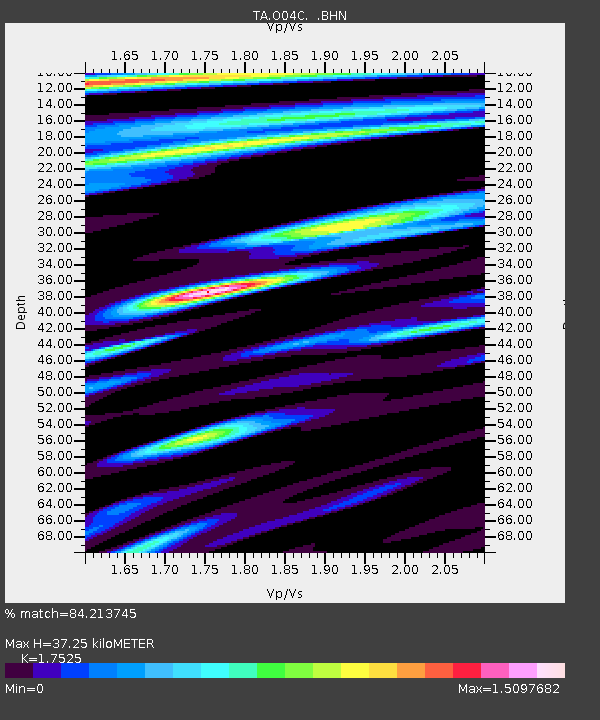
O04C Chester, CA, USA - Earthquake Result Viewer
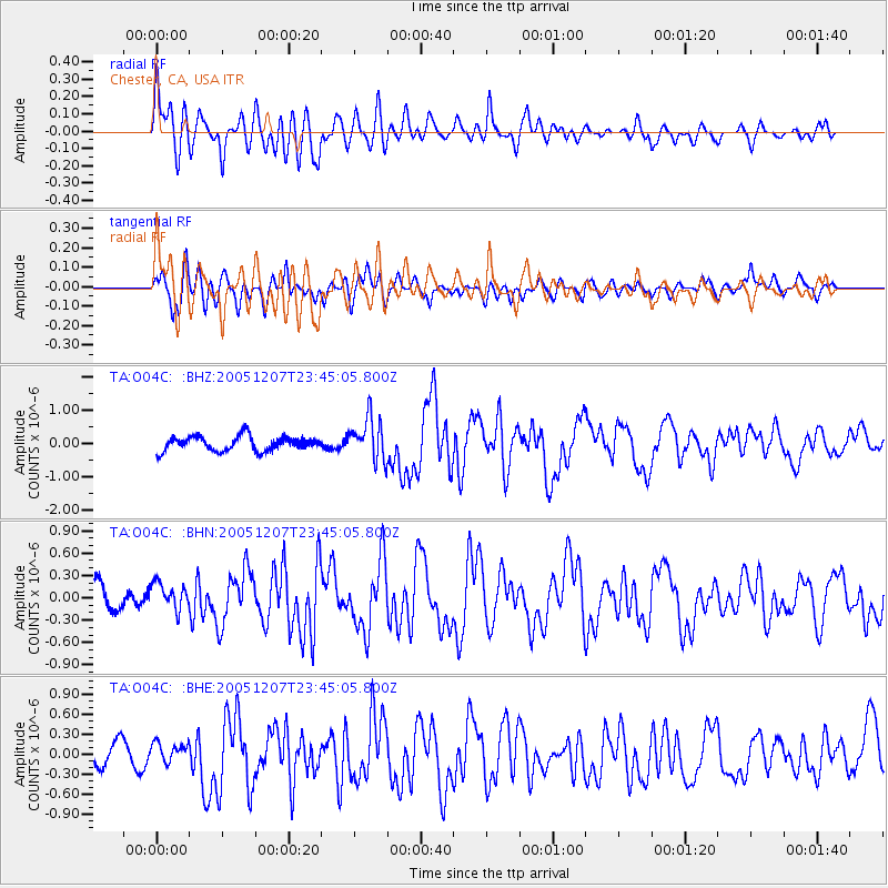
Earthquake location: Kermadec Islands, New Zealand
Earthquake latitude/longitude: -30.0/-177.6
Earthquake time(UTC): 2005/12/07 (341) 23:32:51 GMT
Earthquake Depth: 21 km
Earthquake Magnitude: 6.0 MB, 6.4 MS, 6.4 MW, 6.3 MW
Earthquake Catalog/Contributor: WHDF/NEIC
Network: TA USArray Transportable Network (new EarthScope stations)
Station: O04C Chester, CA, USA
Lat/Lon: 40.32 N/121.09 W
Elevation: 1513 m
Distance: 87.4 deg
Az: 39.687 deg
Baz: 226.422 deg
Ray Param: 0.043310367
Estimated Moho Depth: 37.25 km
Estimated Crust Vp/Vs: 1.75
Assumed Crust Vp: 6.566 km/s
Estimated Crust Vs: 3.747 km/s
Estimated Crust Poisson's Ratio: 0.26
Radial Match: 84.213745 %
Radial Bump: 400
Transverse Match: 68.02869 %
Transverse Bump: 400
SOD ConfigId: 2564
Insert Time: 2010-03-06 04:01:10.167 +0000
GWidth: 2.5
Max Bumps: 400
Tol: 0.001

Signal To Noise

ChannelStoNSTALTA
TA:O04C: :BHN:20051207T23:45:05.800Z0.763953031.797474E-72.3528594E-7
TA:O04C: :BHE:20051207T23:45:05.800Z1.00772331.4949777E-71.48352E-7
TA:O04C: :BHZ:20051207T23:45:05.800Z2.91462766.325051E-72.1701061E-7
Arrivals
Ps4.4 SECOND
PpPs15 SECOND
PsPs/PpSs20 SECOND