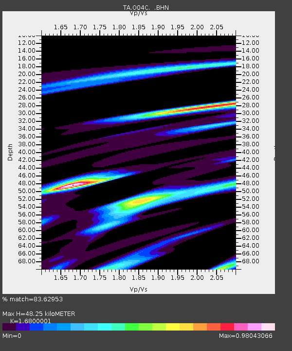
O04C Chester, CA, USA - Earthquake Result Viewer
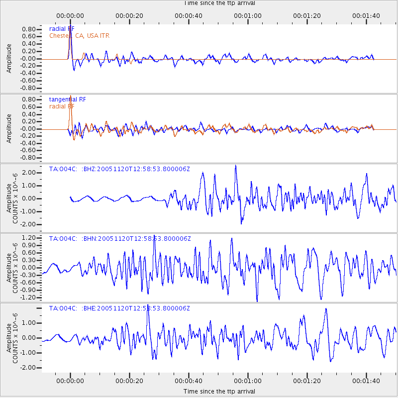
Earthquake location: Unimak Island Region, Alaska
Earthquake latitude/longitude: 53.8/-164.1
Earthquake time(UTC): 2005/11/20 (324) 12:53:02 GMT
Earthquake Depth: 30 km
Earthquake Magnitude: 5.7 MB, 5.8 MS, 6.2 MW, 6.0 MW
Earthquake Catalog/Contributor: WHDF/NEIC
Network: TA USArray Transportable Network (new EarthScope stations)
Station: O04C Chester, CA, USA
Lat/Lon: 40.32 N/121.09 W
Elevation: 1513 m
Distance: 31.7 deg
Az: 97.476 deg
Baz: 309.785 deg
Ray Param: 0.07890808
Estimated Moho Depth: 48.25 km
Estimated Crust Vp/Vs: 1.68
Assumed Crust Vp: 6.566 km/s
Estimated Crust Vs: 3.908 km/s
Estimated Crust Poisson's Ratio: 0.23
Radial Match: 83.62953 %
Radial Bump: 400
Transverse Match: 76.76578 %
Transverse Bump: 400
SOD ConfigId: 132717
Insert Time: 2010-03-06 04:01:11.920 +0000
GWidth: 2.5
Max Bumps: 400
Tol: 0.001

Signal To Noise

ChannelStoNSTALTA
TA:O04C: :BHN:20051120T12:58:53.800006Z1.11465811.5689774E-71.4075863E-7
TA:O04C: :BHE:20051120T12:58:53.800006Z0.94761432.0213423E-72.1330854E-7
TA:O04C: :BHZ:20051120T12:58:53.800006Z1.72375992.4293246E-71.4093173E-7
Arrivals
Ps5.5 SECOND
PpPs18 SECOND
PsPs/PpSs23 SECOND