You are here: Home > Network List > TA - USArray Transportable Network (new EarthScope stations) Stations List
> Station O04C Chester, CA, USA > Earthquake Result Viewer
O04C Chester, CA, USA - Earthquake Result Viewer
| Earthquake location: |
Mariana Islands |
| Earthquake latitude/longitude: |
20.1/145.8 |
| Earthquake time(UTC): |
2005/08/13 (225) 07:36:52 GMT |
| Earthquake Depth: |
49 km |
| Earthquake Magnitude: |
5.8 MB, 5.6 MS, 6.0 MW, 6.0 MW |
| Earthquake Catalog/Contributor: |
WHDF/NEIC |
|
| Network: |
TA USArray Transportable Network (new EarthScope stations) |
| Station: |
O04C Chester, CA, USA |
| Lat/Lon: |
40.32 N/121.09 W |
| Elevation: |
1513 m |
|
| Distance: |
79.5 deg |
| Az: |
50.928 deg |
| Baz: |
287.427 deg |
| Ray Param: |
0.04880443 |
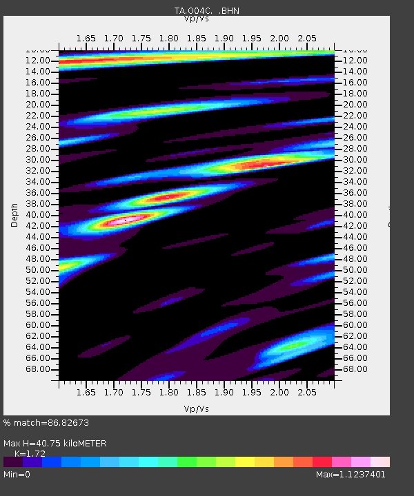
| Estimated Moho Depth: |
40.75 km |
| Estimated Crust Vp/Vs: |
1.72 |
| Assumed Crust Vp: |
6.566 km/s |
| Estimated Crust Vs: |
3.818 km/s |
| Estimated Crust Poisson's Ratio: |
0.24 |
|
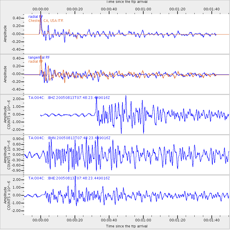
| Radial Match: |
86.82673 % |
| Radial Bump: |
400 |
| Transverse Match: |
91.77548 % |
| Transverse Bump: |
400 |
| SOD ConfigId: |
2422 |
| Insert Time: |
2010-03-06 04:01:16.760 +0000 |
| GWidth: |
2.5 |
| Max Bumps: |
400 |
| Tol: |
0.001 |
|
Signal To Noise
| Channel | StoN | STA | LTA |
| TA:O04C: :BHN:20050813T07:48:23.449016Z | 2.756306 | 2.1383208E-7 | 7.757923E-8 |
| TA:O04C: :BHE:20050813T07:48:23.449016Z | 2.466149 | 2.770748E-7 | 1.123512E-7 |
| TA:O04C: :BHZ:20050813T07:48:23.449016Z | 8.623039 | 7.6237393E-7 | 8.8411284E-8 |
| Arrivals |
| Ps | 4.6 SECOND |
| PpPs | 16 SECOND |
| PsPs/PpSs | 21 SECOND |


