O04C Chester, CA, USA - Earthquake Result Viewer
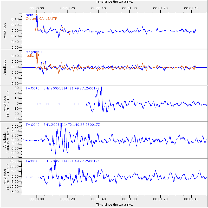
Earthquake location: Off East Coast Of Honshu, Japan
Earthquake latitude/longitude: 38.1/144.9
Earthquake time(UTC): 2005/11/14 (318) 21:38:51 GMT
Earthquake Depth: 11 km
Earthquake Magnitude: 6.7 MB, 6.8 MS, 7.0 MW, 6.9 MW
Earthquake Catalog/Contributor: WHDF/NEIC
Network: TA USArray Transportable Network (new EarthScope stations)
Station: O04C Chester, CA, USA
Lat/Lon: 40.32 N/121.09 W
Elevation: 1513 m
Distance: 69.3 deg
Az: 54.633 deg
Baz: 302.716 deg
Ray Param: 0.055751804
Estimated Moho Depth: 40.75 km
Estimated Crust Vp/Vs: 1.70
Assumed Crust Vp: 6.566 km/s
Estimated Crust Vs: 3.874 km/s
Estimated Crust Poisson's Ratio: 0.23
Radial Match: 95.83917 %
Radial Bump: 400
Transverse Match: 93.37153 %
Transverse Bump: 400
SOD ConfigId: 2448
Insert Time: 2010-03-06 04:01:19.793 +0000
GWidth: 2.5
Max Bumps: 400
Tol: 0.001

Signal To Noise

ChannelStoNSTALTA
TA:O04C: :BHN:20051114T21:49:27.250017Z1.661524.101267E-72.4683825E-7
TA:O04C: :BHE:20051114T21:49:27.250017Z1.85961455.6550545E-73.0409822E-7
TA:O04C: :BHZ:20051114T21:49:27.250017Z11.6399451.9647514E-61.6879386E-7
Arrivals
Ps4.5 SECOND
PpPs16 SECOND
PsPs/PpSs21 SECOND