You are here: Home > Network List > TA - USArray Transportable Network (new EarthScope stations) Stations List
> Station O04C Chester, CA, USA > Earthquake Result Viewer
O04C Chester, CA, USA - Earthquake Result Viewer
| Earthquake location: |
Panama-Costa Rica Border Region |
| Earthquake latitude/longitude: |
8.4/-82.9 |
| Earthquake time(UTC): |
2005/06/30 (181) 21:26:36 GMT |
| Earthquake Depth: |
38 km |
| Earthquake Magnitude: |
5.3 MB, 5.6 MS, 6.0 MW, 5.8 MW |
| Earthquake Catalog/Contributor: |
WHDF/NEIC |
|
| Network: |
TA USArray Transportable Network (new EarthScope stations) |
| Station: |
O04C Chester, CA, USA |
| Lat/Lon: |
40.32 N/121.09 W |
| Elevation: |
1513 m |
|
| Distance: |
46.5 deg |
| Az: |
319.305 deg |
| Baz: |
122.47 deg |
| Ray Param: |
0.0705278 |
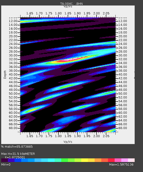
| Estimated Moho Depth: |
31.5 km |
| Estimated Crust Vp/Vs: |
1.87 |
| Assumed Crust Vp: |
6.566 km/s |
| Estimated Crust Vs: |
3.507 km/s |
| Estimated Crust Poisson's Ratio: |
0.30 |
|
| Radial Match: |
85.873665 % |
| Radial Bump: |
400 |
| Transverse Match: |
76.81008 % |
| Transverse Bump: |
400 |
| SOD ConfigId: |
142937 |
| Insert Time: |
2010-03-06 04:01:22.780 +0000 |
| GWidth: |
2.5 |
| Max Bumps: |
400 |
| Tol: |
0.001 |
|
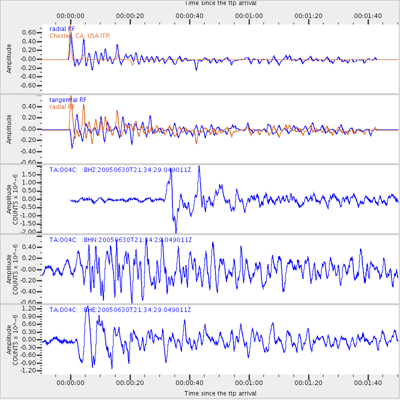
Signal To Noise
| Channel | StoN | STA | LTA |
| TA:O04C: :BHN:20050630T21:34:29.049011Z | 2.3073611 | 1.8320638E-7 | 7.940083E-8 |
| TA:O04C: :BHE:20050630T21:34:29.049011Z | 4.92709 | 4.1022255E-7 | 8.3258584E-8 |
| TA:O04C: :BHZ:20050630T21:34:29.049011Z | 11.288819 | 8.052697E-7 | 7.133338E-8 |
| Arrivals |
| Ps | 4.5 SECOND |
| PpPs | 13 SECOND |
| PsPs/PpSs | 17 SECOND |


