You are here: Home > Network List > TA - USArray Transportable Network (new EarthScope stations) Stations List
> Station O04C Chester, CA, USA > Earthquake Result Viewer
O04C Chester, CA, USA - Earthquake Result Viewer
| Earthquake location: |
Rat Islands, Aleutian Islands |
| Earthquake latitude/longitude: |
51.2/179.4 |
| Earthquake time(UTC): |
2005/06/14 (165) 17:10:16 GMT |
| Earthquake Depth: |
51 km |
| Earthquake Magnitude: |
6.0 MB, 6.8 MW, 6.6 MW |
| Earthquake Catalog/Contributor: |
WHDF/NEIC |
|
| Network: |
TA USArray Transportable Network (new EarthScope stations) |
| Station: |
O04C Chester, CA, USA |
| Lat/Lon: |
40.32 N/121.09 W |
| Elevation: |
1513 m |
|
| Distance: |
41.8 deg |
| Az: |
81.069 deg |
| Baz: |
305.675 deg |
| Ray Param: |
0.073399484 |
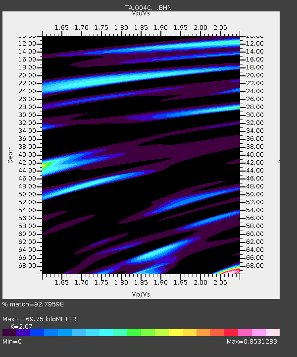
| Estimated Moho Depth: |
69.75 km |
| Estimated Crust Vp/Vs: |
2.07 |
| Assumed Crust Vp: |
6.566 km/s |
| Estimated Crust Vs: |
3.172 km/s |
| Estimated Crust Poisson's Ratio: |
0.35 |
|
| Radial Match: |
92.79598 % |
| Radial Bump: |
400 |
| Transverse Match: |
85.576355 % |
| Transverse Bump: |
400 |
| SOD ConfigId: |
144822 |
| Insert Time: |
2010-03-06 04:01:27.300 +0000 |
| GWidth: |
2.5 |
| Max Bumps: |
400 |
| Tol: |
0.001 |
|
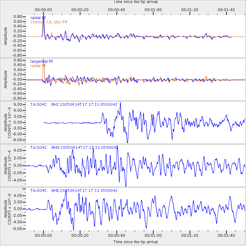
Signal To Noise
| Channel | StoN | STA | LTA |
| TA:O04C: :BHN:20050614T17:17:31.050004Z | 7.3634443 | 6.024954E-7 | 8.182249E-8 |
| TA:O04C: :BHE:20050614T17:17:31.050004Z | 10.262609 | 1.0880588E-6 | 1.06021666E-7 |
| TA:O04C: :BHZ:20050614T17:17:31.050004Z | 17.170462 | 2.0738057E-6 | 1.2077751E-7 |
| Arrivals |
| Ps | 12 SECOND |
| PpPs | 31 SECOND |
| PsPs/PpSs | 43 SECOND |


