You are here: Home > Network List > TA - USArray Transportable Network (new EarthScope stations) Stations List
> Station O04C Chester, CA, USA > Earthquake Result Viewer
O04C Chester, CA, USA - Earthquake Result Viewer

| Earthquake location: |
Chile-Bolivia Border Region |
| Earthquake latitude/longitude: |
-20.0/-68.8 |
| Earthquake time(UTC): |
2005/06/21 (172) 05:11:18 GMT |
| Earthquake Depth: |
105 km |
| Earthquake Magnitude: |
5.4 MB, 5.6 MW, 5.5 MW |
| Earthquake Catalog/Contributor: |
WHDF/NEIC |
|
| Network: |
TA USArray Transportable Network (new EarthScope stations) |
| Station: |
O04C Chester, CA, USA |
| Lat/Lon: |
40.32 N/121.09 W |
| Elevation: |
1513 m |
|
| Distance: |
77.2 deg |
| Az: |
321.676 deg |
| Baz: |
130.288 deg |
| Ray Param: |
0.050217215 |
| Estimated Moho Depth: |
32.0 km |
| Estimated Crust Vp/Vs: |
1.88 |
| Assumed Crust Vp: |
6.566 km/s |
| Estimated Crust Vs: |
3.483 km/s |
| Estimated Crust Poisson's Ratio: |
0.30 |
|
| Radial Match: |
81.02951 % |
| Radial Bump: |
400 |
| Transverse Match: |
66.575935 % |
| Transverse Bump: |
400 |
| SOD ConfigId: |
142939 |
| Insert Time: |
2010-03-06 04:01:32.969 +0000 |
| GWidth: |
2.5 |
| Max Bumps: |
400 |
| Tol: |
0.001 |
|
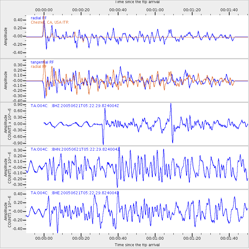
Signal To Noise
| Channel | StoN | STA | LTA |
| TA:O04C: :BHN:20050621T05:22:29.824004Z | 1.518578 | 8.9940606E-8 | 5.9226856E-8 |
| TA:O04C: :BHE:20050621T05:22:29.824004Z | 1.5425209 | 1.6298259E-7 | 1.05659886E-7 |
| TA:O04C: :BHZ:20050621T05:22:29.824004Z | 5.0150027 | 3.387321E-7 | 6.754375E-8 |
| Arrivals |
| Ps | 4.4 SECOND |
| PpPs | 14 SECOND |
| PsPs/PpSs | 18 SECOND |


