You are here: Home > Network List > G - GEOSCOPE Stations List
> Station ATD Arta Cave - Arta, Republic of Djibouti > Earthquake Result Viewer
ATD Arta Cave - Arta, Republic of Djibouti - Earthquake Result Viewer
| Earthquake location: |
Southwest Of Sumatra, Indonesia |
| Earthquake latitude/longitude: |
-4.9/94.2 |
| Earthquake time(UTC): |
2016/03/02 (062) 12:49:46 GMT |
| Earthquake Depth: |
10 km |
| Earthquake Magnitude: |
7.9 MWW |
| Earthquake Catalog/Contributor: |
NEIC PDE/NEIC COMCAT |
|
| Network: |
G GEOSCOPE |
| Station: |
ATD Arta Cave - Arta, Republic of Djibouti |
| Lat/Lon: |
11.53 N/42.85 E |
| Elevation: |
610 m |
|
| Distance: |
53.7 deg |
| Az: |
288.067 deg |
| Baz: |
104.87 deg |
| Ray Param: |
0.06594844 |
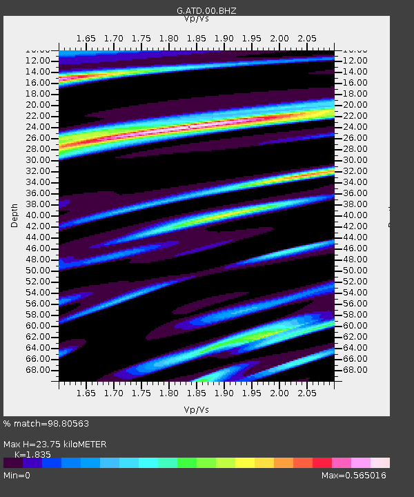
| Estimated Moho Depth: |
23.75 km |
| Estimated Crust Vp/Vs: |
1.84 |
| Assumed Crust Vp: |
6.375 km/s |
| Estimated Crust Vs: |
3.474 km/s |
| Estimated Crust Poisson's Ratio: |
0.29 |
|
| Radial Match: |
98.80563 % |
| Radial Bump: |
374 |
| Transverse Match: |
94.86125 % |
| Transverse Bump: |
400 |
| SOD ConfigId: |
1427151 |
| Insert Time: |
2016-03-16 13:08:14.577 +0000 |
| GWidth: |
2.5 |
| Max Bumps: |
400 |
| Tol: |
0.001 |
|
Signal To Noise
| Channel | StoN | STA | LTA |
| G:ATD:00:BHZ:20160302T12:58:36.950002Z | 6.5503697 | 8.2158357E-7 | 1.2542552E-7 |
| G:ATD:00:BHN:20160302T12:58:36.950002Z | 1.1083027 | 1.516709E-7 | 1.3684972E-7 |
| G:ATD:00:BHE:20160302T12:58:36.950002Z | 3.621484 | 5.470847E-7 | 1.5106643E-7 |
| Arrivals |
| Ps | 3.3 SECOND |
| PpPs | 10 SECOND |
| PsPs/PpSs | 13 SECOND |


