You are here: Home > Network List > TA - USArray Transportable Network (new EarthScope stations) Stations List
> Station O04C Chester, CA, USA > Earthquake Result Viewer
O04C Chester, CA, USA - Earthquake Result Viewer
| Earthquake location: |
Southern Peru |
| Earthquake latitude/longitude: |
-15.3/-73.0 |
| Earthquake time(UTC): |
2005/07/26 (207) 14:11:36 GMT |
| Earthquake Depth: |
110 km |
| Earthquake Magnitude: |
5.8 MB, 6.0 MW, 5.9 MW |
| Earthquake Catalog/Contributor: |
WHDF/NEIC |
|
| Network: |
TA USArray Transportable Network (new EarthScope stations) |
| Station: |
O04C Chester, CA, USA |
| Lat/Lon: |
40.32 N/121.09 W |
| Elevation: |
1513 m |
|
| Distance: |
71.2 deg |
| Az: |
323.021 deg |
| Baz: |
130.62 deg |
| Ray Param: |
0.05423336 |
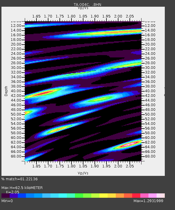
| Estimated Moho Depth: |
62.5 km |
| Estimated Crust Vp/Vs: |
2.05 |
| Assumed Crust Vp: |
6.566 km/s |
| Estimated Crust Vs: |
3.203 km/s |
| Estimated Crust Poisson's Ratio: |
0.34 |
|
| Radial Match: |
81.22136 % |
| Radial Bump: |
400 |
| Transverse Match: |
63.862564 % |
| Transverse Bump: |
400 |
| SOD ConfigId: |
2475 |
| Insert Time: |
2010-03-06 04:01:39.506 +0000 |
| GWidth: |
2.5 |
| Max Bumps: |
400 |
| Tol: |
0.001 |
|
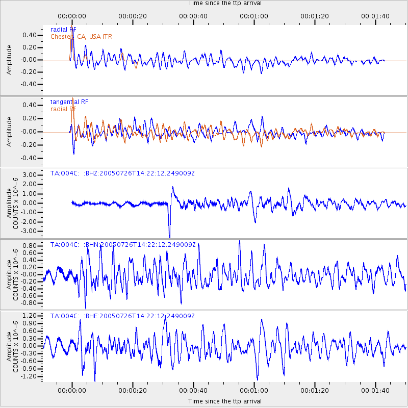
Signal To Noise
| Channel | StoN | STA | LTA |
| TA:O04C: :BHN:20050726T14:22:12.249009Z | 2.7524865 | 3.1721368E-7 | 1.1524622E-7 |
| TA:O04C: :BHE:20050726T14:22:12.249009Z | 2.4689648 | 4.8718425E-7 | 1.973233E-7 |
| TA:O04C: :BHZ:20050726T14:22:12.249009Z | 8.742446 | 1.2048605E-6 | 1.3781732E-7 |
| Arrivals |
| Ps | 10 SECOND |
| PpPs | 28 SECOND |
| PsPs/PpSs | 38 SECOND |


