You are here: Home > Network List > G - GEOSCOPE Stations List
> Station CAN Canberra, Australia > Earthquake Result Viewer
CAN Canberra, Australia - Earthquake Result Viewer

| Earthquake location: |
Southwest Of Sumatra, Indonesia |
| Earthquake latitude/longitude: |
-4.9/94.2 |
| Earthquake time(UTC): |
2016/03/02 (062) 12:49:46 GMT |
| Earthquake Depth: |
10 km |
| Earthquake Magnitude: |
7.9 MWW |
| Earthquake Catalog/Contributor: |
NEIC PDE/NEIC COMCAT |
|
| Network: |
G GEOSCOPE |
| Station: |
CAN Canberra, Australia |
| Lat/Lon: |
35.32 S/149.00 E |
| Elevation: |
650 m |
|
| Distance: |
58.7 deg |
| Az: |
128.612 deg |
| Baz: |
287.809 deg |
| Ray Param: |
0.06265032 |
| Estimated Moho Depth: |
23.25 km |
| Estimated Crust Vp/Vs: |
1.87 |
| Assumed Crust Vp: |
6.633 km/s |
| Estimated Crust Vs: |
3.552 km/s |
| Estimated Crust Poisson's Ratio: |
0.30 |
|
| Radial Match: |
97.784935 % |
| Radial Bump: |
287 |
| Transverse Match: |
96.57161 % |
| Transverse Bump: |
400 |
| SOD ConfigId: |
1427151 |
| Insert Time: |
2016-03-16 13:08:22.222 +0000 |
| GWidth: |
2.5 |
| Max Bumps: |
400 |
| Tol: |
0.001 |
|
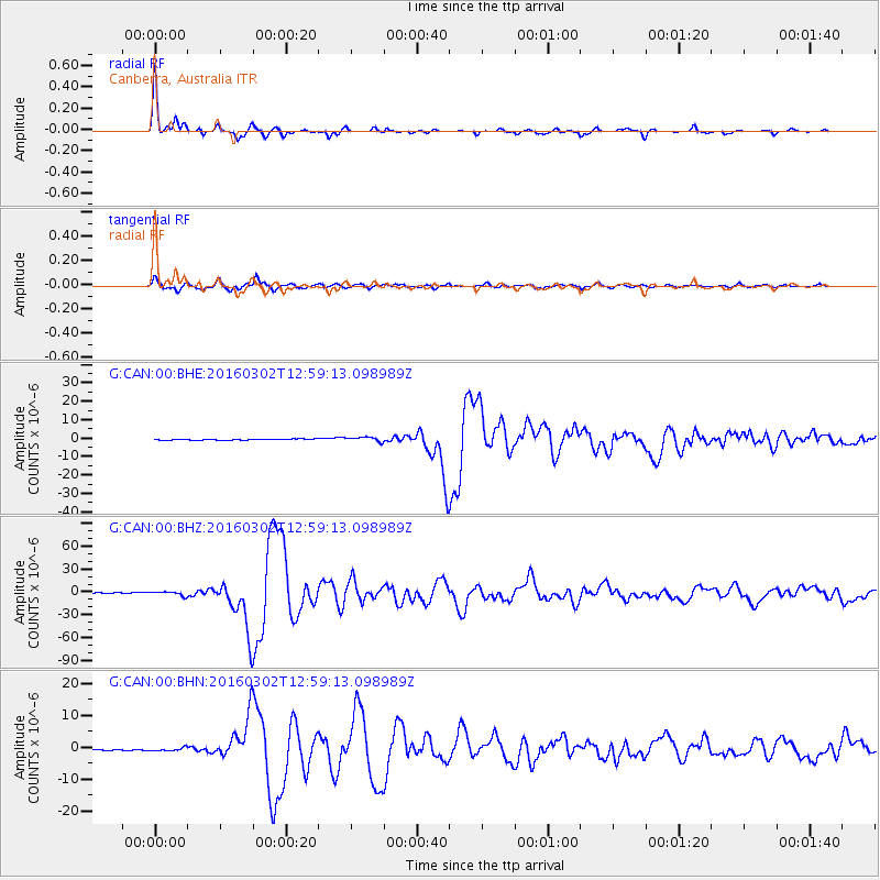
Signal To Noise
| Channel | StoN | STA | LTA |
| G:CAN:00:BHZ:20160302T12:59:13.098989Z | 5.0472813 | 2.7439792E-6 | 5.436549E-7 |
| G:CAN:00:BHN:20160302T12:59:13.098989Z | 2.4826295 | 5.391275E-7 | 2.1715987E-7 |
| G:CAN:00:BHE:20160302T12:59:13.098989Z | 4.866769 | 1.348979E-6 | 2.7718167E-7 |
| Arrivals |
| Ps | 3.2 SECOND |
| PpPs | 9.6 SECOND |
| PsPs/PpSs | 13 SECOND |


