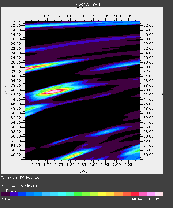
O04C Chester, CA, USA - Earthquake Result Viewer
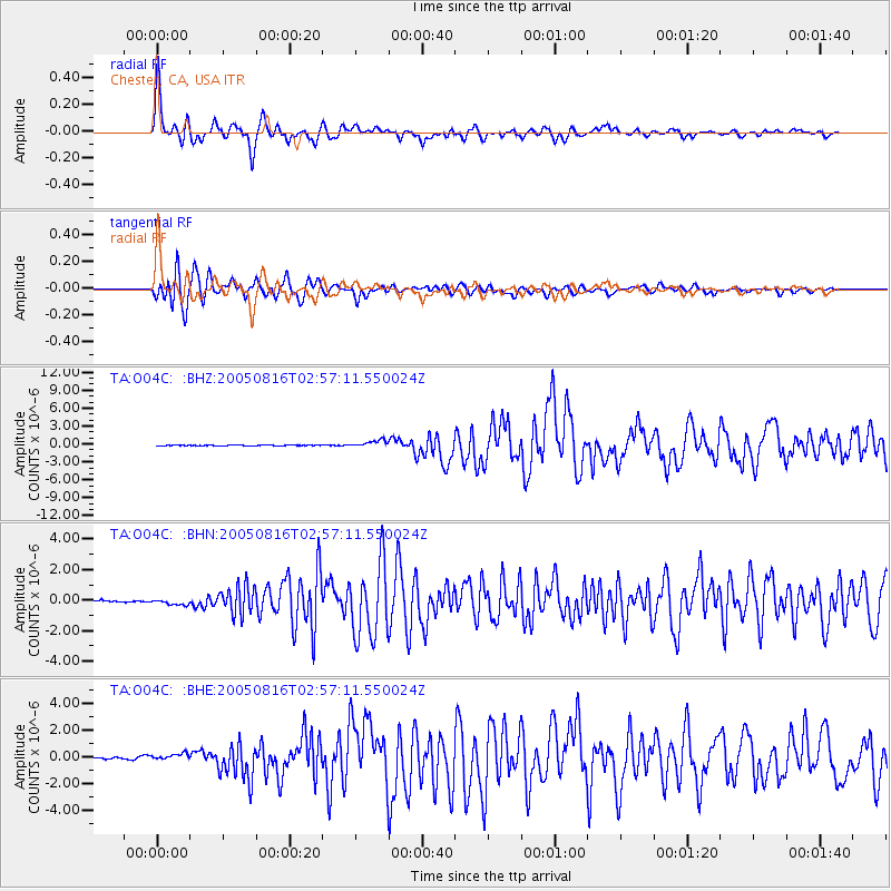
Earthquake location: Near East Coast Of Honshu, Japan
Earthquake latitude/longitude: 38.3/142.0
Earthquake time(UTC): 2005/08/16 (228) 02:46:28 GMT
Earthquake Depth: 36 km
Earthquake Magnitude: 6.5 MB, 6.8 MS, 7.2 MW, 7.1 MW
Earthquake Catalog/Contributor: WHDF/NEIC
Network: TA USArray Transportable Network (new EarthScope stations)
Station: O04C Chester, CA, USA
Lat/Lon: 40.32 N/121.09 W
Elevation: 1513 m
Distance: 71.0 deg
Az: 53.4 deg
Baz: 304.267 deg
Ray Param: 0.05455305
Estimated Moho Depth: 30.5 km
Estimated Crust Vp/Vs: 1.60
Assumed Crust Vp: 6.566 km/s
Estimated Crust Vs: 4.104 km/s
Estimated Crust Poisson's Ratio: 0.18
Radial Match: 94.965416 %
Radial Bump: 400
Transverse Match: 93.157715 %
Transverse Bump: 400
SOD ConfigId: 2475
Insert Time: 2010-03-06 04:01:45.752 +0000
GWidth: 2.5
Max Bumps: 400
Tol: 0.001

Signal To Noise

ChannelStoNSTALTA
TA:O04C: :BHN:20050816T02:57:11.550024Z3.82442021.931485E-75.0503996E-8
TA:O04C: :BHE:20050816T02:57:11.550024Z2.58974842.437041E-79.410339E-8
TA:O04C: :BHZ:20050816T02:57:11.550024Z9.5410086.065625E-76.3574255E-8
Arrivals
Ps2.9 SECOND
PpPs12 SECOND
PsPs/PpSs14 SECOND