You are here: Home > Network List > TA - USArray Transportable Network (new EarthScope stations) Stations List
> Station O04C Chester, CA, USA > Earthquake Result Viewer
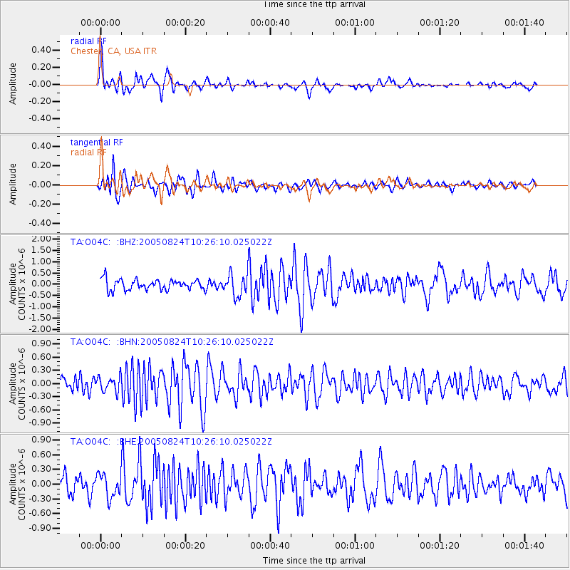
O04C Chester, CA, USA - Earthquake Result Viewer

| Earthquake location: |
Near East Coast Of Honshu, Japan |
| Earthquake latitude/longitude: |
38.6/143.0 |
| Earthquake time(UTC): |
2005/08/24 (236) 10:15:28 GMT |
| Earthquake Depth: |
10 km |
| Earthquake Magnitude: |
6.0 MB, 5.6 MS, 6.2 MW |
| Earthquake Catalog/Contributor: |
WHDF/NEIC |
|
| Network: |
TA USArray Transportable Network (new EarthScope stations) |
| Station: |
O04C Chester, CA, USA |
| Lat/Lon: |
40.32 N/121.09 W |
| Elevation: |
1513 m |
|
| Distance: |
70.2 deg |
| Az: |
53.913 deg |
| Baz: |
304.045 deg |
| Ray Param: |
0.055120952 |
| Estimated Moho Depth: |
39.25 km |
| Estimated Crust Vp/Vs: |
1.76 |
| Assumed Crust Vp: |
6.566 km/s |
| Estimated Crust Vs: |
3.725 km/s |
| Estimated Crust Poisson's Ratio: |
0.26 |
|
| Radial Match: |
83.71765 % |
| Radial Bump: |
400 |
| Transverse Match: |
72.1264 % |
| Transverse Bump: |
400 |
| SOD ConfigId: |
2475 |
| Insert Time: |
2010-03-06 04:01:47.386 +0000 |
| GWidth: |
2.5 |
| Max Bumps: |
400 |
| Tol: |
0.001 |
|
Signal To Noise
| Channel | StoN | STA | LTA |
| TA:O04C: :BHN:20050824T10:26:10.025022Z | 1.1861484 | 1.7485164E-7 | 1.4741126E-7 |
| TA:O04C: :BHE:20050824T10:26:10.025022Z | 0.9216213 | 2.4220043E-7 | 2.627982E-7 |
| TA:O04C: :BHZ:20050824T10:26:10.025022Z | 2.1831946 | 5.0598607E-7 | 2.3176405E-7 |
| Arrivals |
| Ps | 4.7 SECOND |
| PpPs | 16 SECOND |
| PsPs/PpSs | 21 SECOND |


