You are here: Home > Network List > TA - USArray Transportable Network (new EarthScope stations) Stations List
> Station A21K Barrow, AK, USA > Earthquake Result Viewer
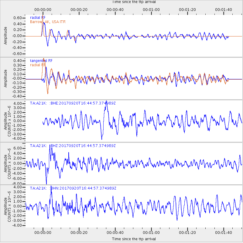
A21K Barrow, AK, USA - Earthquake Result Viewer
*The percent match for this event was below the threshold and hence no stack was calculated.
| Earthquake location: |
Off East Coast Of Honshu, Japan |
| Earthquake latitude/longitude: |
38.0/144.7 |
| Earthquake time(UTC): |
2017/09/20 (263) 16:37:16 GMT |
| Earthquake Depth: |
10 km |
| Earthquake Magnitude: |
6.1 Mww |
| Earthquake Catalog/Contributor: |
NEIC PDE/us |
|
| Network: |
TA USArray Transportable Network (new EarthScope stations) |
| Station: |
A21K Barrow, AK, USA |
| Lat/Lon: |
71.32 N/156.62 W |
| Elevation: |
577 m |
|
| Distance: |
44.6 deg |
| Az: |
23.099 deg |
| Baz: |
254.204 deg |
| Ray Param: |
$rayparam |
*The percent match for this event was below the threshold and hence was not used in the summary stack. |
|
| Radial Match: |
79.83743 % |
| Radial Bump: |
400 |
| Transverse Match: |
52.930103 % |
| Transverse Bump: |
400 |
| SOD ConfigId: |
13570011 |
| Insert Time: |
2019-04-28 20:16:51.294 +0000 |
| GWidth: |
2.5 |
| Max Bumps: |
400 |
| Tol: |
0.001 |
|
Signal To Noise
| Channel | StoN | STA | LTA |
| TA:A21K: :BHZ:20170920T16:44:57.374989Z | 5.76182 | 3.3556314E-6 | 5.823909E-7 |
| TA:A21K: :BHN:20170920T16:44:57.374989Z | 1.9234682 | 1.5098541E-6 | 7.8496436E-7 |
| TA:A21K: :BHE:20170920T16:44:57.374989Z | 2.1875045 | 1.929098E-6 | 8.8187153E-7 |
| Arrivals |
| Ps | |
| PpPs | |
| PsPs/PpSs | |


