You are here: Home > Network List > TA - USArray Transportable Network (new EarthScope stations) Stations List
> Station B21K Ikpikpuk River, AK, USA > Earthquake Result Viewer
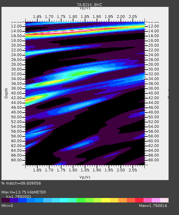
B21K Ikpikpuk River, AK, USA - Earthquake Result Viewer
| Earthquake location: |
Off East Coast Of Honshu, Japan |
| Earthquake latitude/longitude: |
38.0/144.7 |
| Earthquake time(UTC): |
2017/09/20 (263) 16:37:16 GMT |
| Earthquake Depth: |
10 km |
| Earthquake Magnitude: |
6.1 Mww |
| Earthquake Catalog/Contributor: |
NEIC PDE/us |
|
| Network: |
TA USArray Transportable Network (new EarthScope stations) |
| Station: |
B21K Ikpikpuk River, AK, USA |
| Lat/Lon: |
69.62 N/154.61 W |
| Elevation: |
92 m |
|
| Distance: |
44.8 deg |
| Az: |
25.689 deg |
| Baz: |
257.933 deg |
| Ray Param: |
0.071685016 |
| Estimated Moho Depth: |
13.75 km |
| Estimated Crust Vp/Vs: |
1.80 |
| Assumed Crust Vp: |
6.221 km/s |
| Estimated Crust Vs: |
3.466 km/s |
| Estimated Crust Poisson's Ratio: |
0.27 |
|
| Radial Match: |
89.609856 % |
| Radial Bump: |
400 |
| Transverse Match: |
81.89043 % |
| Transverse Bump: |
400 |
| SOD ConfigId: |
13570011 |
| Insert Time: |
2019-04-28 20:16:55.510 +0000 |
| GWidth: |
2.5 |
| Max Bumps: |
400 |
| Tol: |
0.001 |
|

Signal To Noise
| Channel | StoN | STA | LTA |
| TA:B21K: :BHZ:20170920T16:44:59.325001Z | 18.19421 | 3.7343664E-6 | 2.0525026E-7 |
| TA:B21K: :BHN:20170920T16:44:59.325001Z | 2.153846 | 4.3615708E-7 | 2.0250151E-7 |
| TA:B21K: :BHE:20170920T16:44:59.325001Z | 5.8494143 | 8.742364E-7 | 1.4945708E-7 |
| Arrivals |
| Ps | 1.9 SECOND |
| PpPs | 5.8 SECOND |
| PsPs/PpSs | 7.7 SECOND |


