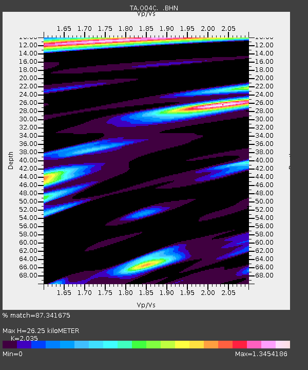
O04C Chester, CA, USA - Earthquake Result Viewer
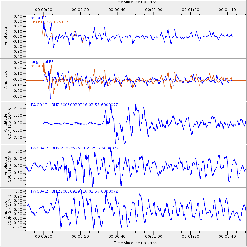
Earthquake location: New Britain Region, P.N.G.
Earthquake latitude/longitude: -5.4/151.8
Earthquake time(UTC): 2005/09/29 (272) 15:50:24 GMT
Earthquake Depth: 25 km
Earthquake Magnitude: 5.9 MB, 6.6 MS, 6.7 MW, 6.5 MW
Earthquake Catalog/Contributor: WHDF/NEIC
Network: TA USArray Transportable Network (new EarthScope stations)
Station: O04C Chester, CA, USA
Lat/Lon: 40.32 N/121.09 W
Elevation: 1513 m
Distance: 91.2 deg
Az: 49.797 deg
Baz: 263.988 deg
Ray Param: 0.04161297
Estimated Moho Depth: 26.25 km
Estimated Crust Vp/Vs: 2.04
Assumed Crust Vp: 6.566 km/s
Estimated Crust Vs: 3.227 km/s
Estimated Crust Poisson's Ratio: 0.34
Radial Match: 87.341675 %
Radial Bump: 400
Transverse Match: 76.27326 %
Transverse Bump: 400
SOD ConfigId: 2475
Insert Time: 2010-03-06 04:01:52.598 +0000
GWidth: 2.5
Max Bumps: 400
Tol: 0.001

Signal To Noise

ChannelStoNSTALTA
TA:O04C: :BHN:20050929T16:02:55.600007Z1.35696022.4224747E-71.7852216E-7
TA:O04C: :BHE:20050929T16:02:55.600007Z1.58175672.2797612E-71.4412844E-7
TA:O04C: :BHZ:20050929T16:02:55.600007Z6.98598245.981654E-78.562366E-8
Arrivals
Ps4.2 SECOND
PpPs12 SECOND
PsPs/PpSs16 SECOND