You are here: Home > Network List > G - GEOSCOPE Stations List
> Station NOUC Port Laguerre, New Caledonia > Earthquake Result Viewer
NOUC Port Laguerre, New Caledonia - Earthquake Result Viewer

| Earthquake location: |
Southwest Of Sumatra, Indonesia |
| Earthquake latitude/longitude: |
-4.9/94.2 |
| Earthquake time(UTC): |
2016/03/02 (062) 12:49:46 GMT |
| Earthquake Depth: |
10 km |
| Earthquake Magnitude: |
7.9 MWW |
| Earthquake Catalog/Contributor: |
NEIC PDE/NEIC COMCAT |
|
| Network: |
G GEOSCOPE |
| Station: |
NOUC Port Laguerre, New Caledonia |
| Lat/Lon: |
22.10 S/166.30 E |
| Elevation: |
112 m |
|
| Distance: |
71.6 deg |
| Az: |
111.551 deg |
| Baz: |
272.175 deg |
| Ray Param: |
0.054245703 |
| Estimated Moho Depth: |
24.0 km |
| Estimated Crust Vp/Vs: |
1.79 |
| Assumed Crust Vp: |
5.14 km/s |
| Estimated Crust Vs: |
2.872 km/s |
| Estimated Crust Poisson's Ratio: |
0.27 |
|
| Radial Match: |
96.27008 % |
| Radial Bump: |
400 |
| Transverse Match: |
93.5621 % |
| Transverse Bump: |
400 |
| SOD ConfigId: |
1427151 |
| Insert Time: |
2016-03-16 13:08:41.206 +0000 |
| GWidth: |
2.5 |
| Max Bumps: |
400 |
| Tol: |
0.001 |
|
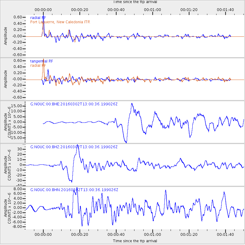
Signal To Noise
| Channel | StoN | STA | LTA |
| G:NOUC:00:BHZ:20160302T13:00:36.199026Z | 1.8439305 | 1.0717386E-6 | 5.812251E-7 |
| G:NOUC:00:BHN:20160302T13:00:36.199026Z | 0.95325655 | 5.0062886E-7 | 5.251775E-7 |
| G:NOUC:00:BHE:20160302T13:00:36.199026Z | 1.7397765 | 9.1992047E-7 | 5.287578E-7 |
| Arrivals |
| Ps | 3.8 SECOND |
| PpPs | 13 SECOND |
| PsPs/PpSs | 17 SECOND |


