You are here: Home > Network List > TA - USArray Transportable Network (new EarthScope stations) Stations List
> Station D24K Happy Valley, AK, USA > Earthquake Result Viewer
D24K Happy Valley, AK, USA - Earthquake Result Viewer
| Earthquake location: |
Off East Coast Of Honshu, Japan |
| Earthquake latitude/longitude: |
38.0/144.7 |
| Earthquake time(UTC): |
2017/09/20 (263) 16:37:16 GMT |
| Earthquake Depth: |
10 km |
| Earthquake Magnitude: |
6.1 Mww |
| Earthquake Catalog/Contributor: |
NEIC PDE/us |
|
| Network: |
TA USArray Transportable Network (new EarthScope stations) |
| Station: |
D24K Happy Valley, AK, USA |
| Lat/Lon: |
69.15 N/148.82 W |
| Elevation: |
292 m |
|
| Distance: |
46.8 deg |
| Az: |
26.783 deg |
| Baz: |
264.111 deg |
| Ray Param: |
0.07043797 |
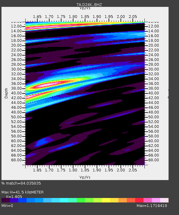
| Estimated Moho Depth: |
41.5 km |
| Estimated Crust Vp/Vs: |
1.61 |
| Assumed Crust Vp: |
6.316 km/s |
| Estimated Crust Vs: |
3.935 km/s |
| Estimated Crust Poisson's Ratio: |
0.18 |
|
| Radial Match: |
84.035835 % |
| Radial Bump: |
400 |
| Transverse Match: |
79.45021 % |
| Transverse Bump: |
400 |
| SOD ConfigId: |
13570011 |
| Insert Time: |
2019-04-28 20:17:09.651 +0000 |
| GWidth: |
2.5 |
| Max Bumps: |
400 |
| Tol: |
0.001 |
|
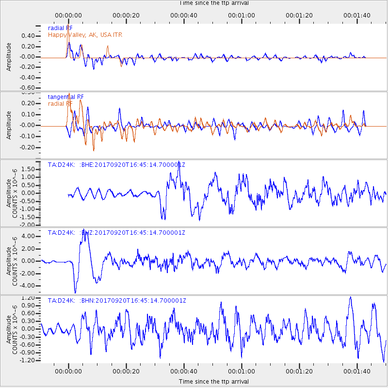
Signal To Noise
| Channel | StoN | STA | LTA |
| TA:D24K: :BHZ:20170920T16:45:14.700001Z | 22.394238 | 2.421275E-6 | 1.0812045E-7 |
| TA:D24K: :BHN:20170920T16:45:14.700001Z | 1.8587627 | 2.7110156E-7 | 1.4585054E-7 |
| TA:D24K: :BHE:20170920T16:45:14.700001Z | 4.0496597 | 7.610191E-7 | 1.8792174E-7 |
| Arrivals |
| Ps | 4.2 SECOND |
| PpPs | 16 SECOND |
| PsPs/PpSs | 20 SECOND |


