You are here: Home > Network List > TA - USArray Transportable Network (new EarthScope stations) Stations List
> Station F31M Tsiigehtchic, NWT, CAN > Earthquake Result Viewer
F31M Tsiigehtchic, NWT, CAN - Earthquake Result Viewer
| Earthquake location: |
Off East Coast Of Honshu, Japan |
| Earthquake latitude/longitude: |
38.0/144.7 |
| Earthquake time(UTC): |
2017/09/20 (263) 16:37:16 GMT |
| Earthquake Depth: |
10 km |
| Earthquake Magnitude: |
6.1 Mww |
| Earthquake Catalog/Contributor: |
NEIC PDE/us |
|
| Network: |
TA USArray Transportable Network (new EarthScope stations) |
| Station: |
F31M Tsiigehtchic, NWT, CAN |
| Lat/Lon: |
67.44 N/133.74 W |
| Elevation: |
56 m |
|
| Distance: |
52.4 deg |
| Az: |
28.795 deg |
| Baz: |
279.429 deg |
| Ray Param: |
0.06677632 |
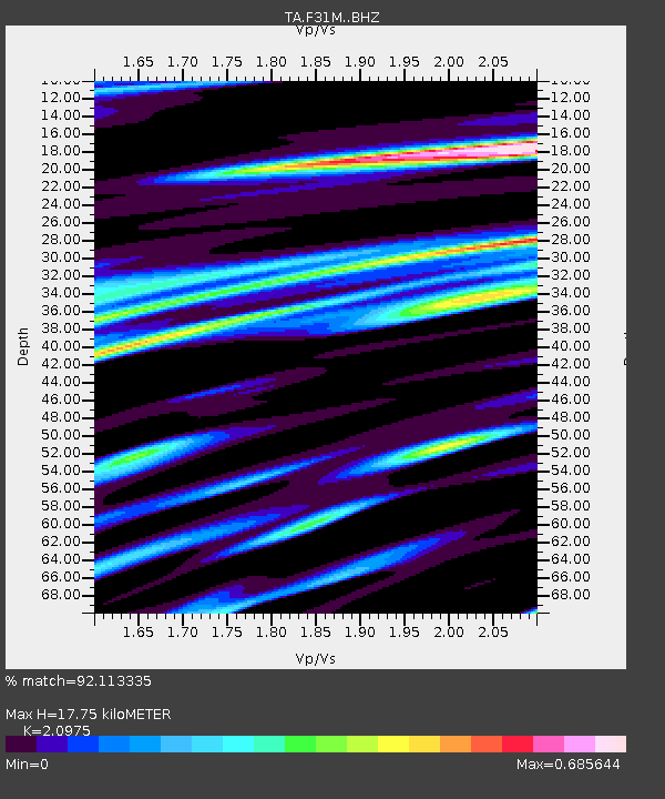
| Estimated Moho Depth: |
17.75 km |
| Estimated Crust Vp/Vs: |
2.10 |
| Assumed Crust Vp: |
6.171 km/s |
| Estimated Crust Vs: |
2.942 km/s |
| Estimated Crust Poisson's Ratio: |
0.35 |
|
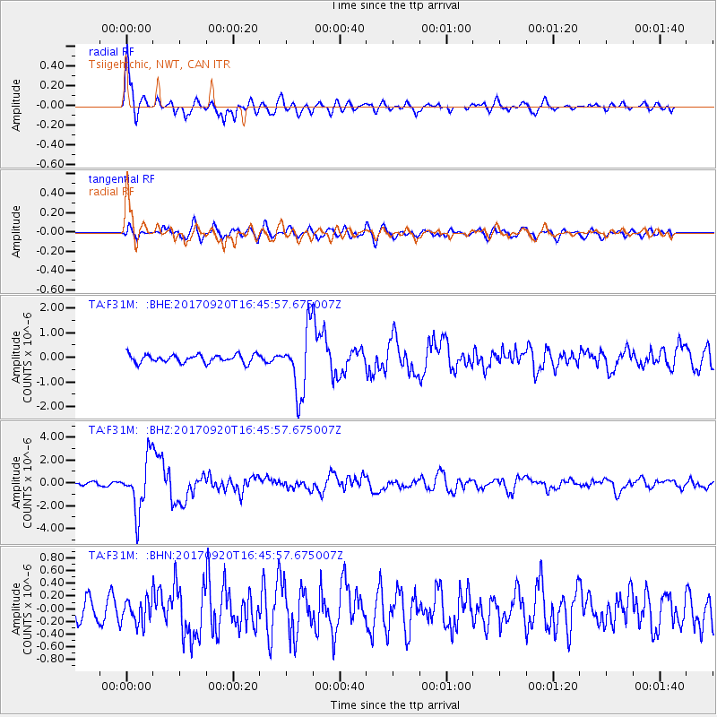
| Radial Match: |
92.113335 % |
| Radial Bump: |
400 |
| Transverse Match: |
74.29629 % |
| Transverse Bump: |
400 |
| SOD ConfigId: |
13570011 |
| Insert Time: |
2019-04-28 20:17:29.458 +0000 |
| GWidth: |
2.5 |
| Max Bumps: |
400 |
| Tol: |
0.001 |
|
Signal To Noise
| Channel | StoN | STA | LTA |
| TA:F31M: :BHZ:20170920T16:45:57.675007Z | 16.279448 | 2.3265814E-6 | 1.4291525E-7 |
| TA:F31M: :BHN:20170920T16:45:57.675007Z | 1.4951302 | 1.8747107E-7 | 1.253878E-7 |
| TA:F31M: :BHE:20170920T16:45:57.675007Z | 8.078421 | 1.3011005E-6 | 1.6105878E-7 |
| Arrivals |
| Ps | 3.3 SECOND |
| PpPs | 8.5 SECOND |
| PsPs/PpSs | 12 SECOND |


