You are here: Home > Network List > G - GEOSCOPE Stations List
> Station RER Riviere de l'Est, La Reunion (Indian Ocean) > Earthquake Result Viewer
RER Riviere de l'Est, La Reunion (Indian Ocean) - Earthquake Result Viewer
| Earthquake location: |
Southwest Of Sumatra, Indonesia |
| Earthquake latitude/longitude: |
-4.9/94.2 |
| Earthquake time(UTC): |
2016/03/02 (062) 12:49:46 GMT |
| Earthquake Depth: |
10 km |
| Earthquake Magnitude: |
7.9 MWW |
| Earthquake Catalog/Contributor: |
NEIC PDE/NEIC COMCAT |
|
| Network: |
G GEOSCOPE |
| Station: |
RER Riviere de l'Est, La Reunion (Indian Ocean) |
| Lat/Lon: |
21.16 S/55.75 E |
| Elevation: |
834 m |
|
| Distance: |
40.7 deg |
| Az: |
243.038 deg |
| Baz: |
72.075 deg |
| Ray Param: |
0.074262775 |
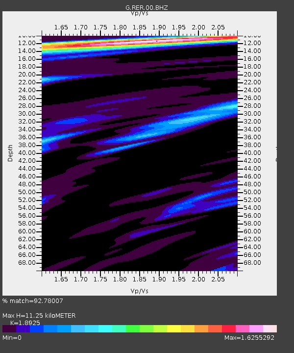
| Estimated Moho Depth: |
11.25 km |
| Estimated Crust Vp/Vs: |
1.89 |
| Assumed Crust Vp: |
4.73 km/s |
| Estimated Crust Vs: |
2.499 km/s |
| Estimated Crust Poisson's Ratio: |
0.31 |
|
| Radial Match: |
92.78007 % |
| Radial Bump: |
400 |
| Transverse Match: |
82.5632 % |
| Transverse Bump: |
400 |
| SOD ConfigId: |
1427151 |
| Insert Time: |
2016-03-16 13:08:53.997 +0000 |
| GWidth: |
2.5 |
| Max Bumps: |
400 |
| Tol: |
0.001 |
|
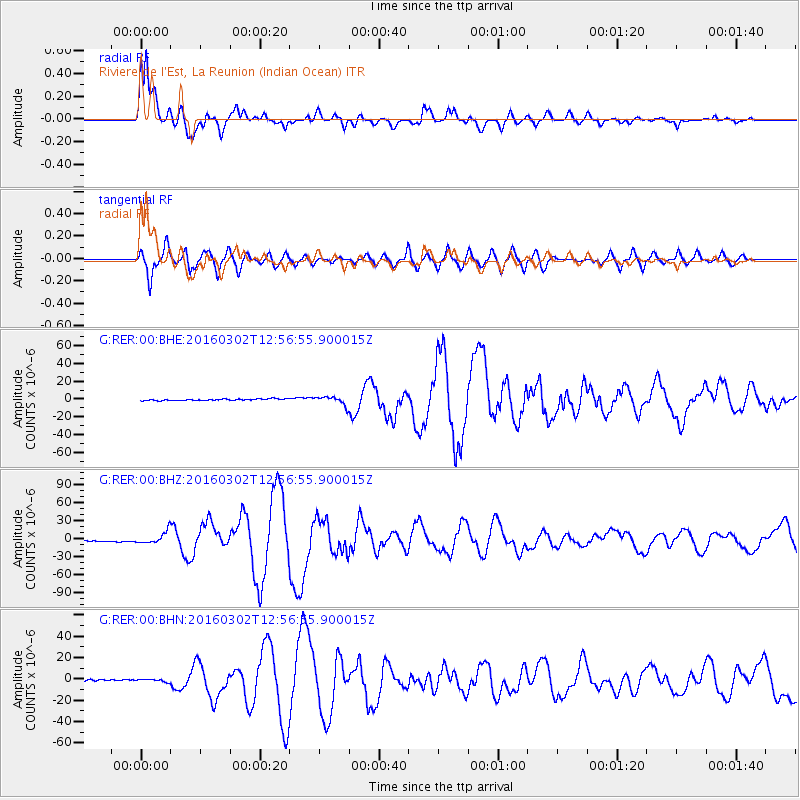
Signal To Noise
| Channel | StoN | STA | LTA |
| G:RER:00:BHZ:20160302T12:56:55.900015Z | 9.855236 | 9.906246E-6 | 1.0051759E-6 |
| G:RER:00:BHN:20160302T12:56:55.900015Z | 2.1923394 | 1.2822096E-6 | 5.8485904E-7 |
| G:RER:00:BHE:20160302T12:56:55.900015Z | 5.229724 | 4.5503316E-6 | 8.700903E-7 |
| Arrivals |
| Ps | 2.2 SECOND |
| PpPs | 6.6 SECOND |
| PsPs/PpSs | 8.8 SECOND |


