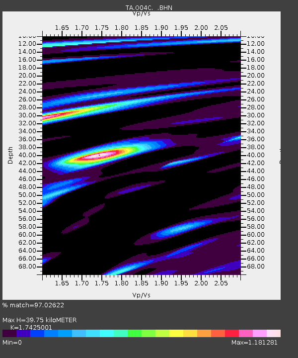
O04C Chester, CA, USA - Earthquake Result Viewer
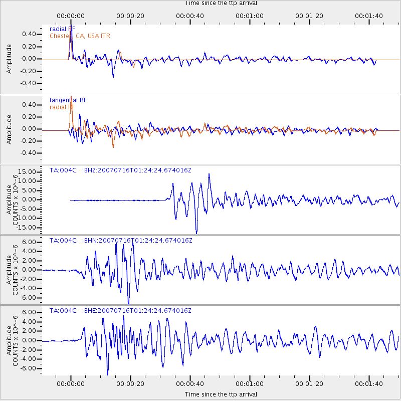
Earthquake location: Near West Coast Of Honshu, Japan
Earthquake latitude/longitude: 37.5/138.4
Earthquake time(UTC): 2007/07/16 (197) 01:13:22 GMT
Earthquake Depth: 12 km
Earthquake Magnitude: 6.5 MB, 6.4 MS, 6.6 MW, 6.5 MW
Earthquake Catalog/Contributor: WHDF/NEIC
Network: TA USArray Transportable Network (new EarthScope stations)
Station: O04C Chester, CA, USA
Lat/Lon: 40.32 N/121.09 W
Elevation: 1513 m
Distance: 73.7 deg
Az: 51.566 deg
Baz: 305.468 deg
Ray Param: 0.052822538
Estimated Moho Depth: 39.75 km
Estimated Crust Vp/Vs: 1.74
Assumed Crust Vp: 6.566 km/s
Estimated Crust Vs: 3.768 km/s
Estimated Crust Poisson's Ratio: 0.25
Radial Match: 97.02622 %
Radial Bump: 400
Transverse Match: 94.77112 %
Transverse Bump: 400
SOD ConfigId: 2564
Insert Time: 2010-03-06 04:02:04.968 +0000
GWidth: 2.5
Max Bumps: 400
Tol: 0.001

Signal To Noise

ChannelStoNSTALTA
TA:O04C: :BHN:20070716T01:24:24.674016Z9.9599966.1807293E-76.205554E-8
TA:O04C: :BHE:20070716T01:24:24.674016Z13.525581.0308775E-67.621688E-8
TA:O04C: :BHZ:20070716T01:24:24.674016Z62.6096572.8601141E-64.5681677E-8
Arrivals
Ps4.7 SECOND
PpPs16 SECOND
PsPs/PpSs21 SECOND