You are here: Home > Network List > TA - USArray Transportable Network (new EarthScope stations) Stations List
> Station G22K Bettles, AK, USA > Earthquake Result Viewer
G22K Bettles, AK, USA - Earthquake Result Viewer
| Earthquake location: |
Off East Coast Of Honshu, Japan |
| Earthquake latitude/longitude: |
38.0/144.7 |
| Earthquake time(UTC): |
2017/09/20 (263) 16:37:16 GMT |
| Earthquake Depth: |
10 km |
| Earthquake Magnitude: |
6.1 Mww |
| Earthquake Catalog/Contributor: |
NEIC PDE/us |
|
| Network: |
TA USArray Transportable Network (new EarthScope stations) |
| Station: |
G22K Bettles, AK, USA |
| Lat/Lon: |
66.92 N/151.51 W |
| Elevation: |
205 m |
|
| Distance: |
45.5 deg |
| Az: |
29.725 deg |
| Baz: |
263.662 deg |
| Ray Param: |
0.07122247 |
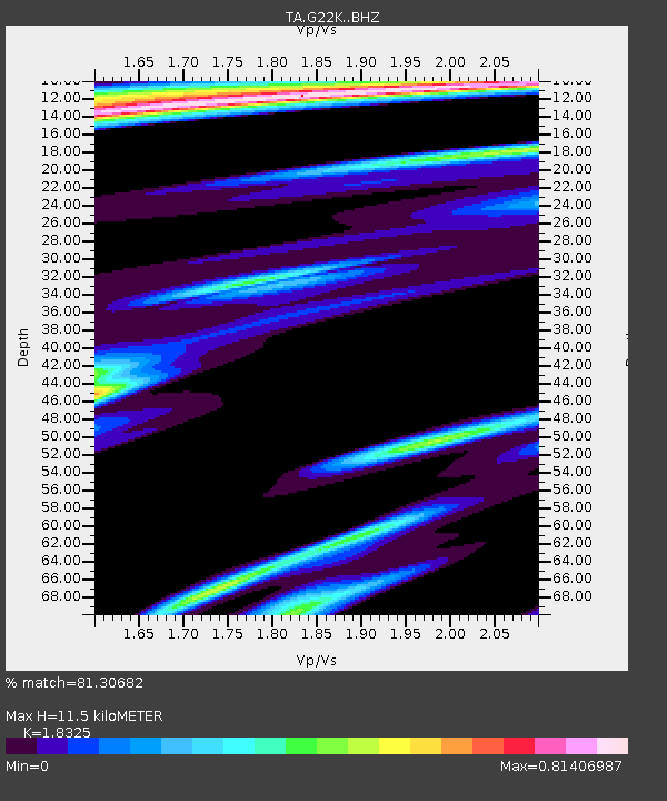
| Estimated Moho Depth: |
11.5 km |
| Estimated Crust Vp/Vs: |
1.83 |
| Assumed Crust Vp: |
6.577 km/s |
| Estimated Crust Vs: |
3.589 km/s |
| Estimated Crust Poisson's Ratio: |
0.29 |
|
| Radial Match: |
81.30682 % |
| Radial Bump: |
400 |
| Transverse Match: |
79.27944 % |
| Transverse Bump: |
400 |
| SOD ConfigId: |
13570011 |
| Insert Time: |
2019-04-28 20:17:34.807 +0000 |
| GWidth: |
2.5 |
| Max Bumps: |
400 |
| Tol: |
0.001 |
|
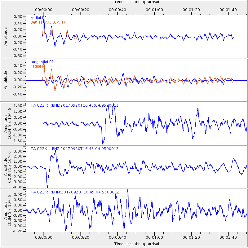
Signal To Noise
| Channel | StoN | STA | LTA |
| TA:G22K: :BHZ:20170920T16:45:04.950001Z | 20.442144 | 1.7763437E-6 | 8.689615E-8 |
| TA:G22K: :BHN:20170920T16:45:04.950001Z | 1.8449394 | 2.0989486E-7 | 1.1376789E-7 |
| TA:G22K: :BHE:20170920T16:45:04.950001Z | 10.816199 | 1.0012209E-6 | 9.256679E-8 |
| Arrivals |
| Ps | 1.6 SECOND |
| PpPs | 4.6 SECOND |
| PsPs/PpSs | 6.2 SECOND |


