You are here: Home > Network List > G - GEOSCOPE Stations List
> Station ROCAM Leguat Reserve, Rodrigues Island, Republic of Mauritius > Earthquake Result Viewer
ROCAM Leguat Reserve, Rodrigues Island, Republic of Mauritius - Earthquake Result Viewer
| Earthquake location: |
Southwest Of Sumatra, Indonesia |
| Earthquake latitude/longitude: |
-4.9/94.2 |
| Earthquake time(UTC): |
2016/03/02 (062) 12:49:46 GMT |
| Earthquake Depth: |
10 km |
| Earthquake Magnitude: |
7.9 MWW |
| Earthquake Catalog/Contributor: |
NEIC PDE/NEIC COMCAT |
|
| Network: |
G GEOSCOPE |
| Station: |
ROCAM Leguat Reserve, Rodrigues Island, Republic of Mauritius |
| Lat/Lon: |
19.76 S/63.37 E |
| Elevation: |
52 m |
|
| Distance: |
33.5 deg |
| Az: |
241.156 deg |
| Baz: |
67.918 deg |
| Ray Param: |
0.07818844 |
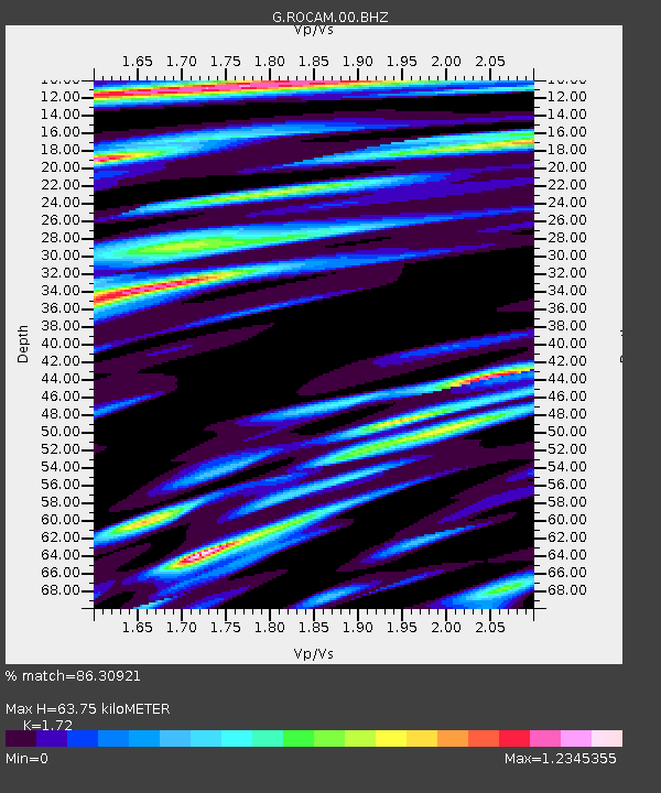
| Estimated Moho Depth: |
63.75 km |
| Estimated Crust Vp/Vs: |
1.72 |
| Assumed Crust Vp: |
4.802 km/s |
| Estimated Crust Vs: |
2.792 km/s |
| Estimated Crust Poisson's Ratio: |
0.24 |
|
| Radial Match: |
86.30921 % |
| Radial Bump: |
386 |
| Transverse Match: |
77.740845 % |
| Transverse Bump: |
390 |
| SOD ConfigId: |
1427151 |
| Insert Time: |
2016-03-16 13:09:00.707 +0000 |
| GWidth: |
2.5 |
| Max Bumps: |
400 |
| Tol: |
0.001 |
|

Signal To Noise
| Channel | StoN | STA | LTA |
| G:ROCAM:00:BHZ:20160302T12:55:54.799001Z | 9.340274 | 1.3684432E-5 | 1.4650997E-6 |
| G:ROCAM:00:BHN:20160302T12:55:54.799001Z | 3.2821069 | 3.7562786E-6 | 1.1444718E-6 |
| G:ROCAM:00:BHE:20160302T12:55:54.799001Z | 4.755509 | 7.025496E-6 | 1.4773384E-6 |
| Arrivals |
| Ps | 10.0 SECOND |
| PpPs | 35 SECOND |
| PsPs/PpSs | 45 SECOND |


