You are here: Home > Network List > TA - USArray Transportable Network (new EarthScope stations) Stations List
> Station G30M túh Zraii Njik, YT, CAN > Earthquake Result Viewer
G30M túh Zraii Njik, YT, CAN - Earthquake Result Viewer
| Earthquake location: |
Off East Coast Of Honshu, Japan |
| Earthquake latitude/longitude: |
38.0/144.7 |
| Earthquake time(UTC): |
2017/09/20 (263) 16:37:16 GMT |
| Earthquake Depth: |
10 km |
| Earthquake Magnitude: |
6.1 Mww |
| Earthquake Catalog/Contributor: |
NEIC PDE/us |
|
| Network: |
TA USArray Transportable Network (new EarthScope stations) |
| Station: |
G30M túh Zraii Njik, YT, CAN |
| Lat/Lon: |
66.98 N/136.22 W |
| Elevation: |
739 m |
|
| Distance: |
51.5 deg |
| Az: |
29.557 deg |
| Baz: |
277.615 deg |
| Ray Param: |
0.06735881 |
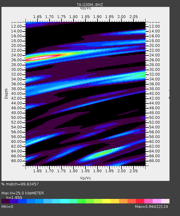
| Estimated Moho Depth: |
25.0 km |
| Estimated Crust Vp/Vs: |
1.65 |
| Assumed Crust Vp: |
6.522 km/s |
| Estimated Crust Vs: |
3.941 km/s |
| Estimated Crust Poisson's Ratio: |
0.21 |
|
| Radial Match: |
89.63457 % |
| Radial Bump: |
400 |
| Transverse Match: |
81.9046 % |
| Transverse Bump: |
400 |
| SOD ConfigId: |
13570011 |
| Insert Time: |
2019-04-28 20:17:40.330 +0000 |
| GWidth: |
2.5 |
| Max Bumps: |
400 |
| Tol: |
0.001 |
|

Signal To Noise
| Channel | StoN | STA | LTA |
| TA:G30M: :BHZ:20170920T16:45:51.099995Z | 23.428925 | 2.5463744E-6 | 1.0868507E-7 |
| TA:G30M: :BHN:20170920T16:45:51.099995Z | 2.4707918 | 4.5222666E-7 | 1.8302904E-7 |
| TA:G30M: :BHE:20170920T16:45:51.099995Z | 9.06461 | 1.5321895E-6 | 1.6902983E-7 |
| Arrivals |
| Ps | 2.7 SECOND |
| PpPs | 9.6 SECOND |
| PsPs/PpSs | 12 SECOND |


